
In a month when folks across New Jersey, Pennsylvania and Maryland wondered if ongoing drought conditions would worsen due to a persistent dry and hot pattern, Mother Nature brought a very wet end to July. Due to a stalled frontal boundary and a plume of moisture rich air streaming from the Gulf of Mexico, widespread and beneficial rainfall fell on July 30th and 31st. Many received 0.5 – 2 inches of rain which helped ease drought concerns and saved many from finishing July with nearly 50% rainfall deficits. However, pockets of slow moving storms dumped exceptionally high rainfall in a matter of just minutes in localized areas leading to extreme flash flooding. The most notable cases occurred near Princeton, NJ, Readington, NJ, Bloomingdale, NJ and Ellicott City, MD, the most prolific of which occurred in Ellicott City.

Let’s break it down to show just how historic some of the flooding was in the hardest hit areas. Places near Princeton, NJ received an amazing 5 – 7 inches of rain in just 5 hours on July 30th! To put this into perspective, 4.95 inches of rain normally accumulates over the entire month. There was even a period where nearly 2 inches of rain fell in just 30 minutes which correlates to a 1 in 25 year event (for those interested in a technical definition, a 1 in 25 year event has a 4% chance of being exceeded one time in any given year in a particular location). Due to the record rainfall, rivers and streams in the area overtopped their banks leading to numerous street closures. As seen in the graph below, the Millstone River even reached moderate flood stage!

Then on July 31st, areas near Readington, NJ and Bloomingdale, NJ received an incredible 4 – 5 inches of rain after having already received over 3 inches during the prior two days! The nearly 8 inches of rain measured during the three day stretch ranks as a 1 in 25 – 50 year event. Needless to say, the deluge of rain in just a few short hours led to numerous rescues as cars were submerged by flood waters and the cancellation of New Jersey Hot Air Balloon festival.
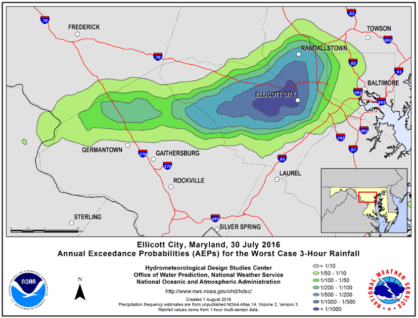
By far, the most impressive event was the historic flooding in Ellicott City, MD, just a few miles west of Baltimore. Repeated torrential downpours for three consecutive hours dumped an unbelievable 6.60 inches of rain, with 4.56 inches dumped in only one hour! That's about the entire month's normal rainfall in just one hour! Probabilities for such an event to occur in this area are less than 1 in 1,000 (or less than 0.1 percent… according to the NOAA’S Hydrometeorological Design Studies Center). The ensuing flood waters devastated much of the downtown area as the Patapsco River rose very, very fast and created an incredible rush of water down the city streets. Not only did the flood take with it numerous cars, but two people sadly lost their lives.
Oh man. Just got to walk down Main Street in Ellicott City. One word: Destruction. pic.twitter.com/csaPnHED09
— Kevin Rector (@RectorSun) July 31, 2016
Flash flooding is dangerous when it occurs. Not all instances are as extreme as those pointed out above, but it is important to know deadly flash flooding can occur quickly and presents a real threat to life and property. While most rainfall received during the end of July was very beneficial, some areas just got too much rain, too fast.


