
When it comes to severe weather, June is certainly no slouch. Back in 2013 two derechos, containing strong winds, a few isolated tornadoes, and hail, plowed through nearly 1000 miles of U.S. real estate on June 12 and 13th. Let’s take a ride back in time to review these derechos and what made them so notable.
Before going back to 2013, though, let’s first explain what constitutes a derecho. A derecho, by definition is1: a widespread, long-lived, “straight-line” windstorm. It is a type of a mesoscale convective system, or a MCS. Derechos are usually associated with lines of fast moving storms, such as a bow-echo or a squall line. Lines of storms occur fairly frequently, however, to be a derecho, the Storm Prediction Center has put forth criteria that must be met. They are:
• A swath of wind damage at least 240 miles long.
• Wind gusts of at least 58 mph for much of the storm’s length. (Can have much higher wind gusts, 75 – 100+ mph have been recorded)
If you are interested in more information about derechos, you can visit our previous blog, which provides a more in-depth look.
.png)
Ideal derecho set up on the left, along with a derecho cross section on the right.
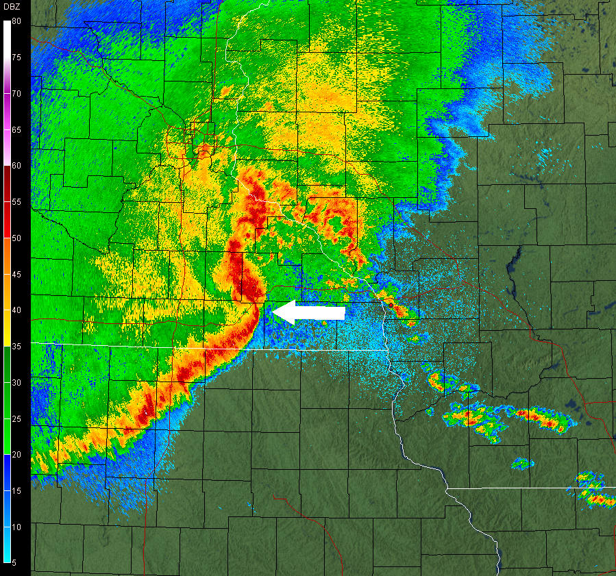
Now we can rewind back. On the morning of June 12th, 2013, an upper level system pushed into the Northern Plains. Much of the southern and eastern United States were under the influence of warm, moist air, thanks to high pressure in the Gulf of Mexico. As the day progressed, instability rose, helping to set off supercell thunderstorms in the upper Midwest. The storms increased in coverage during the mid-afternoon, with even five tornadoes touching down in Iowa. By the evening, the supercells organized into a squall line as it crossed into the Ohio River Valley. As it pushed eastward overnight, hail up to 2.0”+ in diameter fell in Ohio, with strong wind gusts downing many trees and power lines. By 6 AM on the 13th, the line was cutting through the Appalachians at around 40 mph. Hail still fell, though smaller than earlier in the night, but plenty of 40+ mph winds blew as it moved into New Jersey and the Delmarva around 10 AM. By noon, the derecho exited into the Atlantic Ocean. In all, over 150 reports of damaging winds were recorded2.

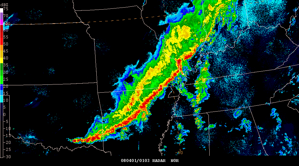
Timing of the June 12th-13th and June 13th derechos, along with storm reports. Courtesy of NOAA.
That wouldn’t be all, though. As the first derecho was exiting off the East Coast, another group of supercells were developing in Ohio during the late morning. Moving into the afternoon, the supercells formed into another line of storms. Wind damage reports increased as it raced southeast into Kentucky and West Virginia, meeting derecho criteria in West Virginia and Virginia. In addition, a few EF 0 and EF 1 tornadoes were spawned, which unfortunately occurred in populated areas. Two tornadoes were confirmed in the northwest suburbs of Washington D.C., while three tornadoes spun-up in the northern suburbs of Atlanta, injuring nine people. By 6 PM, the derecho stretched from southern New Jersey all the way through Alabama, before diminishing over the Atlantic Ocean by 10 PM. In all, over 400 wind reports were observed from the second derecho, with hail sporadically reported as well3.

Although we marked the two year anniversary of these derechos in June, July does not mean derecho season is over. In fact, the peak season for derechos lasts until the end of July. On average, the Midwest sees one derecho per year, decreasing to one derecho every four years along the East Coast.
1 - http://www.spc.noaa.gov/misc/AbtDerechos/derechofacts.htm#definition


