Today marks the 125th anniversary of the landfall of the September 8th, 1900 Galveston, Texas Hurricane. This storm remains one of the most impactful weather events in American history. It still holds the record as the deadliest natural disaster in U.S. history and was a pivotal factor in reshaping the economic and cultural trajectory of the city of Galveston.
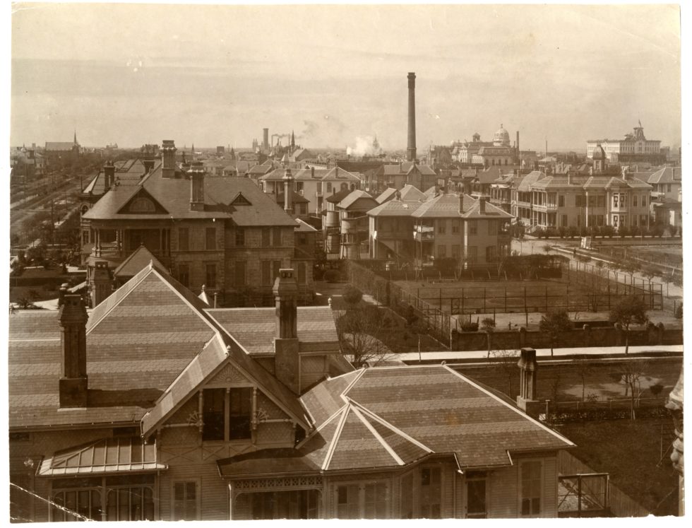 A View of Galveston in the late 1800s - Courtesy of Art Work of Galveston, 1894
Galveston, located on a small, low-lying barrier island in southeast Texas (with a highest elevation of around 8 feet), was a thriving port city at the turn of the 20th century. It was renowned for its deep-water harbor and port, which led the nation in exports of several key commodities; most notably cotton, with nearly 60% of it shipped through Galveston. These economic advantages fueled the city’s prosperity, reflected in its elaborate architecture and vibrant social scene. According to the Galveston & Texas History Center, the city proudly claimed to be the “third richest city in the United States in proportion to its population.” Additionally, the Galveston strand was also nicknamed “The Wall Street of the South” according to the Mitchell Historic Properties. However, the prospects of this thriving city would dramatically alter after the hurricane in 1900.
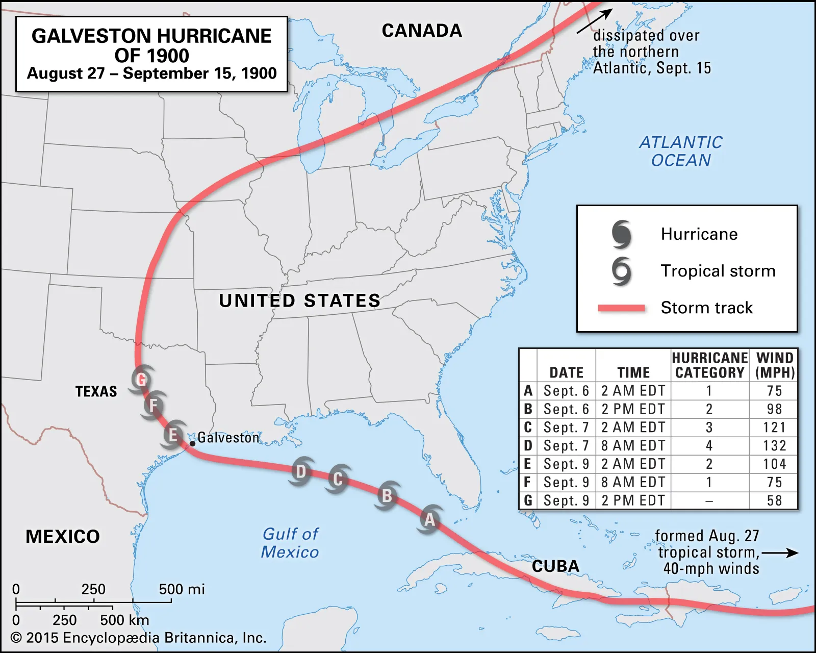
The 1900 hurricane season had been quiet up until Tropical Storm One (tropical cyclones weren’t given official names until 1953) formed on August 27th east of the Windward Islands. The storm tracked westward through the Atlantic, entering the northern Caribbean Sea by the end of the month. This tropical system made it's first landfall on the island of Hispaniola on September 1st as a weak tropical storm. A few days later on September 3rd, it made a second landfall near the modern day Santiago de Cuba Province.
By September 5th, the storm entered the southeastern Gulf of Mexico. Forecasters at the U.S. Weather Bureau (which later became the National Weather Service in 1970) believed the storm had already made a turn north toward Florida. This prompted them to issue warnings from the Florida Keys up toward the eastern coastline of Florida and eventually extended to Savannah, Georgia. However, Cuban meteorologists at the time correctly predicted the storm would continue it's westward movement, noting a shift in track on September 6th.
The U.S. Weather Bureau at this point did confirm the storm had moved west instead into the Gulf and strengthened into a Category 3 hurricane. At this point, hurricane watches were then issued on September 7th from New Orleans to the Texas coastline, which included the city of Galveston. On that same day, the local Weather Bureau manager in Galveston broke protocol and issued a rogue hurricane warning, as warnings and watches were supposed to come from the national office.
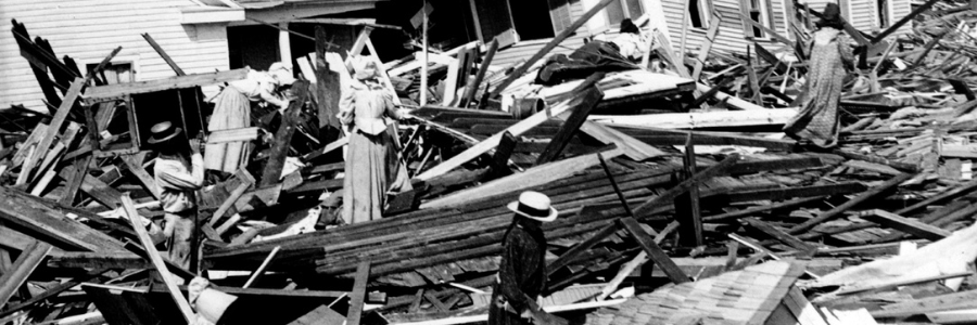
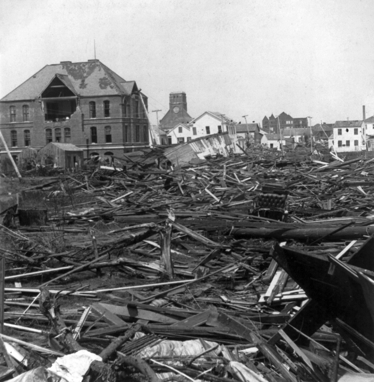
The storm’s effects began to be felt in Galveston on the morning of September 8th and worsened throughout the day. The hurricane intensified to Category 4 status with sustained winds of 140 mph. The worst conditions occurred during the afternoon and evening, with catastrophic storm surge up to 15 feet across the island. Something to note here is that maximum elevation of the island of Galveston is 8 feet. Nearly the entire island was submerged, compounded by destructive wind gusts up to 140 mph. The hurricane made landfall around 8 PM CST. The lowest pressure recorded on the island was 936 mb (27.64 inHg), measured before the instruments failed due to the storm’s intensity. Although the storm weakened quickly after landfall, Galveston was left in complete devastation.
The damage to Galveston, Texas was catastrophic. Initial reports noted that every street had water damage and most buildings also suffered tremendous wind damage. Bridges and railways connecting the island to the mainland were wiped out. Nearly all buildings were damaged and many swept off their foundations and obliterated. Structures that were designed to withstand hurricanes were also completely destroyed.
The death toll for the hurricane is officially estimated to be 8,000 lives, though some accounts have it pinned as high as 12,000. In any case, this makes it the deadliest natural disaster in U.S. history. Approximately 6,000 of those official deaths occurred in Galveston alone, representing 20% of the island’s pre-storm population, which was roughly 40,000.
Property damage was difficult to quantify, but estimates place the loss between $28–30 million (equivalent to roughly $1 billion in 2025 dollars). Over 3,600 homes were destroyed, and around 10,000 people (25% of the island’s population) were left homeless. Many key infrastructure elements and buildings were either heavily damaged or completely lost.
The storm’s severity had long-lasting consequences for the city of Galveston. One of those was a mass exodus, as parts of the city became uninhabitable and residents sought shelter and employment elsewhere, most notably in Houston. This migration foreshadowed Houston’s rise as the dominant city in southeast Texas, in terms of both population and cultural influence.
As Galveston’s economy collapsed, much of its industry also relocated to Houston. Being farther inland, Houston was much less vulnerable to direct hurricane impacts. It's infrastructure, especially the railroad network and port facilities, expanded rapidly. The development of the Houston Ship Channel further accelerated this shift. By the mid-20th century, Houston had fully overtaken Galveston as the region’s economic and cultural center.
Galveston did eventually recover, but it never regained its pre-storm prominence. Today, it remains a smaller city with an economy largely centered around tourism. While tourism helped Galveston reinvent itself in recent memory, it was not able to restore its former status as a major port along the Texas coastline. In response to the disaster, the city implemented significant safety measures. Most notably, it constructed a 17-foot-high, 10-mile-long seawall along the Gulf shore, completed in 1904. Additionally, the city raised its elevation several feet to reduce future flooding risks.


