
Snow in early October is a rare sight in the Northeast US, and it's certainly not something most people would expect. But nearly 40 years ago, on October 4th in 1987, residents of Albany, New York woke up to a shocking scene: several inches of snow blanketing the ground. The surprise extended beyond the public, as local meteorologists were also caught off guard. More than six inches of snow fell in Albany itself, with even higher totals in nearby areas, bringing the region to a standstill. So, how did a snowstorm happen so early in the season and with little notice? Lets discuss it.
Evolution of the Storm
The atmospheric setup for this storm was unusually favorable for early-season snowfall. An abnormal dip in the jet stream allowed cold air from Canada to funnel into Upstate New York and parts of New England. This pattern was triggered by a slow-moving cold front that stalled over New England, followed by the development of a low-pressure system along that front just off the coast of New Jersey.
As the system rapidly intensified and tracked north-northeast into Connecticut and Massachusetts, its central pressure dropped from 1004 mb to 992 mb. This strengthening of the storm allowed for some enhanced precipitation to fall, along with colder air to filter down into the area.
The storm began as rain late day on October 3rd across Albany, eastern upstate New York, portions of Vermont, and western Massachusetts and Connecticut. By the overnight hours, temperatures started to funnel down, with rain beginning to mix over to wet snow. Now, tempeartures were not below freezing at the surface, as temperatures hovered around 33 - 34°F in Albany. However, the intensity of precipitation, along with it occuring at night, allowed the snow to accumulate. The snow ended up being quite heavy and dense, with a a slushy layer at the base of the snowpack from a combination of rain and relatively warm grounds, which are typical for early October.
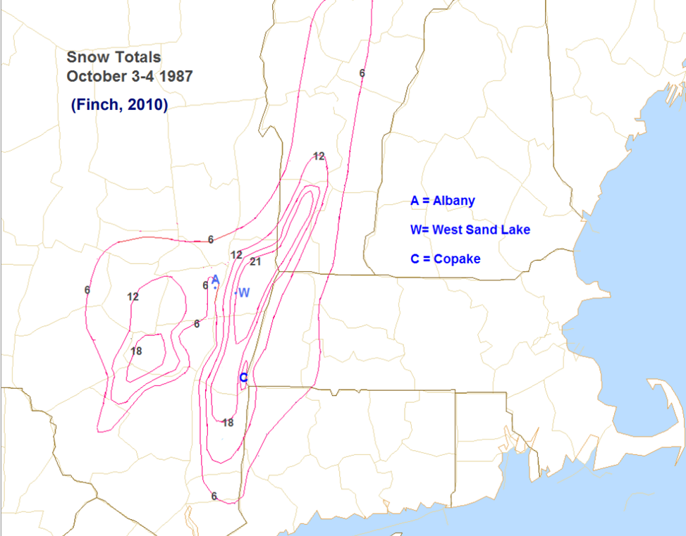
Map of snow totals on October 4th, 1987 - Courtesy of the National Weather Service
Storm Impacts
This unprecedented early-season snowstorm brought the Capital District and surrounding areas of Upstate NY to a standstill. Because snow occured quite early in the year, along with forecasts not being able to pick up on the cold air, this event caught residents and officials off-guard, amplifying the disruptive effects.
Albany recorded approximately 6.5 inches of snow, though higher elevations saw totals anywhere from 12 and 18 inches. As mentioned, the snow was quite dense and heavy, and with many of the trees still being leafed, this ended up causing numerous down branches and widespread power outages. More than 200,000 homes and businesses lost electricity, with the storm damage so great, that it led to some without power for weeks!
School districts across the region were closed for at least one day, through some remained shut for up to a week. In response to the severity of the storm, then-Governor of New York, Mario Cuomo, declared a disaster declaration for the counties of Albany, Columbia, Rensselaer, Dutchess, Greene, and Montgomery, allowing the state to increase funds and resources to help with clean-up operations.

Snowfall in Brunswick, NY, just outside of Albany - Courtesy of the National Weather Service
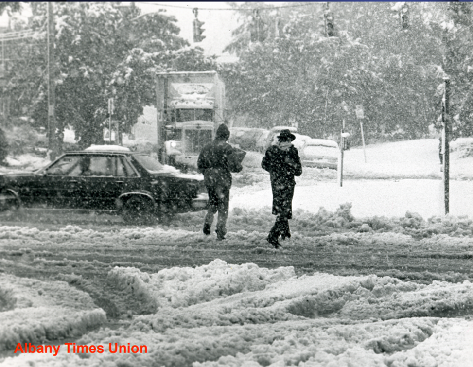
Image of Albany, NY during the October 4th, 1987 Event - Jack Madigan/ The Albany Times Union
What Went Wrong with the Forecast?
It's quite clear that the general public was surprised by this event, but even to officials and meteorologists at the time. To put it bluntly, the forecast for this event was significantly off. No local meteorologist was predicting snow, so it was quite the head turner when residents across the area woke up to a winter-like scene.
There were several reasons for this missed forecast. First, there was no historical precedent for a snowstorm this early in the season, which made it quite difficult to anticipate it occurring. Meteorologists sometimes like looking at past events to help predict what may happen in the future. We call these "Analog" events. However, there was no storm in recorded weather history before that time which compared to what occurred. Second, the storm intensified much more quickly than expected, which allowed cold air to sink farther south and reach the Capital District more effectively. A process called "Dynamic Cooling" is likely the culpret of the storm. This is when strengthening storms produce strong upward motion and heavy precipitation is able to bring cooler/colder air to the surface.
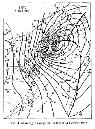 Surface Map of the Snowstorm Intensifying - Lance F. Bosart & Frederick Sanders 1991
And finally, one of the obvious answers to the forecast flub was the inferior weather forecasting tools of the time. Weather models back in 1987 were far less advanced than they are today. On top of that, no meteorologist would have even though of it, given that it was in October and there were good signals at the time of the storm being rather weak. Of course today, we likely would have had some "hints" of snow being a possibility, though it very well could have still been an overperformer.


