
Last winter featured little cold and snow in much of the Midwest and eastern United States. In fact, January and February featured record warmth in the Ohio Valley, Mid-Atlantic, and Northeast. The presence of La Niña and a strongly negative PDO (cooler waters off the West Coast of the US) were largely to blame for the lack of winter last year. We are now nearing the end of summer, and some are probably already wondering what the upcoming winter has in store. We took a look at some early signals, and yes, there is already a very different pattern driver in place compared to last year, and that would be El Niño.

Courtesy of Tropical Tidbits
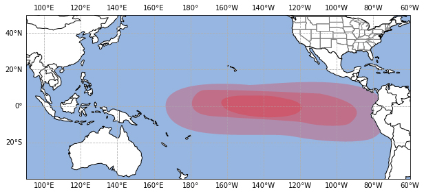
The image above shows the current sea surface temperature anomalies around the globe, and you can indeed see a healthy El Niño developing across the equatorial Pacific. All indications point to this El Niño continuing to develop and likely achieving moderate to strong status for the upcoming winter season. The strength of El Niño is important, but its placement has even more impact on the overall weather pattern. El Niños are either east-based, west-based, or basin-wide.

Typical East Based El Niño Sea Surface Temperature Anomalies
Typical Basin Wide El Niño Sea Surface Temperature Anomalies
Each of these placements has distinct impacts on the weather pattern, with east-based El Niños producing some of the warmer winters. With it not even being calendar fall yet, there is no way to say with certainty which kind of El Niño we will see this winter. However, we are currently favoring more of a basin-wide El Niño, which does provide some hope of more cold and snow this winter.
Another factor we are closely monitoring is the sea surface temperature pattern in the northern Pacific, as we are coming off of one of the strongest negative PDOs on record. The map above shows that the sea surface temperature configuration has changed somewhat over the past few months, but still resembles somewhat of a negative PDO (if anything). There are indications that this will become netural at some point, but it likely won't help the cause of sustained cold in the eastern United States, especially early this winter.
We took the above factors and some others into account to come up with our initial analog years (these are years with similar conditions) to give us an idea of what the trough and ridge pattern may be like this winter:

WeatherWorks analog jet stream pattern for the 2023-2024 winter
You can see that this pattern looks much different than what we have been seeing with La Niña the past few winters. The subtropical jet stream will likely be active this year, allowing for frequent systems to track across the southern United States and perhaps up the East Coast. Whether the risk of a bigger East Coast winter storm or two has merit will ultimately depend on whether the polar jet stream can dip into the Eastern United States. An active pattern doesn't mean a snowy one, and Greenland blocking is one factor we are watching that could help produce more troughs in the East and increase the potential for higher-impact snow events, particularly towards mid-late winter.
![]()
WeatherWorks temperature outlook for December - February

WeatherWorks precipitation outlook for December - February
Our first call for the winter currently favors the northern part of the country to see above-normal temperatures and less cold outbreaks than normal. Due to the southern United States being more active than normal, the coolest temperatures relative to normal are actually favored in this part of the country. As far as the Ohio Valley, Mid-Atlantic, and Northeast, we are favoring a mild start to winter before risks for more cold spells increase later on in the season. Despite how much more snow falls this year compared to last year being uncertain, it wouldn't be surprising to us if most of the snow in the Mid-Atlantic and Northeast occurs in a few storms, as this is not uncommon in El Niño winters. One thing we are a bit more confident in at this time is that the Pacific Northwest and Great Lakes will see a drier than normal winter due to the main storm track staying south.


