
We continue to march through the 2023 Hurricane Season, with a little less than a month left until we reach the climatological peak of the season. There's already been a ton of talk about the record-shattering sea surface temperatures across the basin as well as the maturing El Nino. In this update, we'll be taking a look at how the season has performed thus far and what we can expect for the remainder of the season.
We started the season off right on cue, with Arlene developing from a stalled frontal boundary in the Gulf of Mexico on June 1st. The small system only lasted around two days and peaked at 40 mph before strong shear and dry air caused the system to dissipate in the Gulf. Things quickly became much more interesting around two weeks later, as a pair of strong tropical waves rolled off of Africa and into the eastern Atlantic. The first wave developed into Tropical Storm Bret on June 19th and set a record for a tropical storm forming this far east so early in the season. The wave behind Bret then gradually organized and eventually developed into Tropical Storm Cindy on June 22nd, which set another record for the only time two storms have formed this far east in the month of June. Bret and Cindy peaked at 70 mph and 60 mph, respectively, before eventually succumbing to shear and dry air near the Lesser Antilles. Activity eased through early July before a non-tropical low became trapped over the far northern Atlantic. This system would go on to become Don, which lasted around 10 days and peaked as a low-end hurricane before eventually fading out to sea.

A look back at the unusually active Atlantic in June (Image Courtesy of cyclonicwx.com)
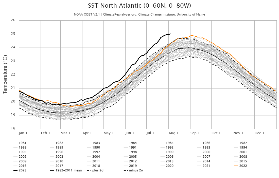
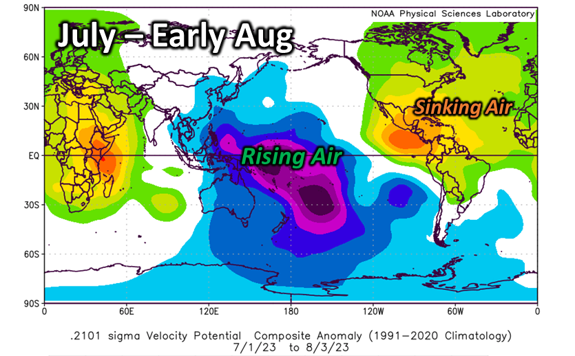
The Atlantic has had a few disturbances that have tried to develop since Don, but none have actually been able to sustain themselves and cross the threshold of becoming a named tropical cyclone. So, where do we go from here? The Atlantic still remains extremely warm, with sea surface temperatures already running well above what they should be. In fact, water temperatures are already ahead of where a "typical" season would peak (see below)! Normally this would lead us to believe that this season would be a shoo-in for an extremely active season, but thankfully we do have some other factors at play that have been keeping things in check. First off, there's been a good deal of "sinking" air over the Atlantic since the beginning of July, which has worked to suppress thunderstorms and organized development of tropical waves pushing off Africa. Additionally, while wind shear has been lower than average across the basin, we still have a narrow stripe of strong shear from the Lesser Antilles and into the North Atlantic, which has also worked to tear apart these tropical waves as they head west.
The combination of shear and widespread sinking air (see below) have been counteracting warm ocean temperatures and should keep the Atlantic relatively quiet through the middle of August. During the second half of the month, a more favorable pattern may begin working in. With shear and sinking air decreasing over the coming weeks, these waves off Africa can begin developing across the "main development region" of the Atlantic. However, the forecast becomes increasingly complex as the El Niño across the Pacific continues to mature into the peak of the season. While increased storm activity is favored through the first half of September, it'll be crucial to see if El Niño allows for the return of increased shear (which is typical) and a more permanent sinking air regime, which would make anything more than an "average" season difficult to achieve.
With all this in mind, we continue to expect a near-average to slightly above-normal season with 12–16 storms, 4–8 hurricanes, and around 2–4 major hurricanes (total including the unnamed January system and activity through early August). As we broke down above, there are some caveats this season, which can sway numbers up and down. If El Niño effects are on the early side, then we'd tend to see the lower side of the storm count, but if its increased shear is late, then a higher count is possible with the extremely warm sea surfaces temperatures. Regardless of the total number of storms, everyone from the Gulf to the East Coast will need to remain vigilant this year as these record SSTs will provide a higher-than-normal "ceiling" for any storms that do manage to find themselves in a favorable environment.

WeatherWorks thoughts on favored storm tracks this season
In terms of storm tracks, the analog upper air patterns continue to support a fair number of storms escaping out to sea, despite a few tracking across much of the Atlantic. Our analogs also support some storms possibly impacting Florida or the Gulf, mainly from tropical waves that take a bit of time to get going. However, if a stronger storm were to develop, it is more likely it would skirt parts of the Southeast or even New England rather than make a direct landfall in the United States. Overall, we are expecting a low probability of direct impacts from Virginia to New England with the highest risk of direct impacts occurring from the Carolinas to Florida. Again, it's best to keep a close eye on the tropics over the next two months as it only takes one storm to turn a quiet season into a memorable one!


