Memorial Day is considered to be the unofficial start to the summer season, with graduation season in full swing and outdoor gatherings taking place like trips to the beach or time by the grill. And with Memorial Day right around the corner, let’s take a look at some typical weather seen over the past several years, as well as some extremes that have occurred during this Holiday.
For most of its' history (first being observed nationally in 1868), Memorial Day (previously known as Decoration Day) was observed on May 30th each year. It wasn’t until about a century after it's founding that Congress changed the observance of this holiday to the last Monday in the month of May, starting in 1968. Regardless of the date it falls, its' place at the tail end of May has it on the cusp of both spring and summer extremes.
With Memorial Day this year occuring on May 25th, here is a look at some averages and extremes of that day over the last 25 years for select cities in the Northeast and Midwest US.

Looking at climatology over the last quarter-century, Memorial Day typically has seen some form of rainfall, anywhere from one-third to one-half of the time. Washout conditions of a half inch or more make up about one-quarter to one-third of the time. Temperatures also average on the warmer side, with many in the 70s to 80s, even in the 80s on some more rare occasions. And of course, with those more unsettled patterns, it's common to see temperatures in the 50s and 60s.
With Memorial Day falling in the final stretches of spring (and right on the cusp of meteorological summer), severe weather tends to be the most common form of extreme weather seen during the holiday weekend.
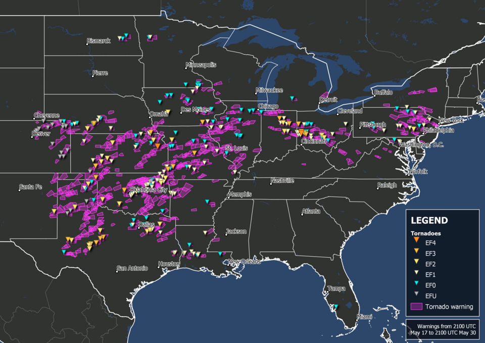
One such instance was the Memorial Day Tornado Outbreak of 2019, which saw a destructive series of tornadoes rip through Indiana and Ohio the evening of May 27th, which ended up being the fourth costliest weather event in Ohio's history. A total of 60 tornadoes occurred on the 27th, seven of which were EF-3 or above (one EF-4 was reported). That one EF-4 tornado passed through the Dayton, OH area, resulting in $500 million in damages, 166 injuries, and one indirect fatality.
Late-May typically isn't thought of as being the time for snowstorms, however on May 28th - 29th a major snowstorm crossed the Central Plains and moved into the Upper Midwest, bringing with it moderate snowfall across the region just in time for Memorial Day (which was on the 30th that year). Cold air from Canada entrenched the the Upper Midwest with temperatures in the 30s and 40s. A swath from northern Iowa into Wisconsin saw incredible late-season snowfall, with 8" in Cherokee, Iowa, 10" in Gays Mills, Wisconsin, and 9" in Viroqua, Wisconsin.
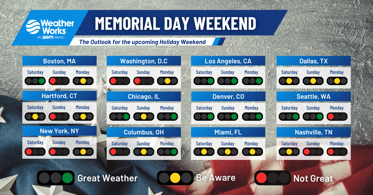
So, what are we expecting as we head into this holiday weekend? Well lets take a look at some select cities across the county. We're using traffic lights in the graphic above to display how ideal or not ideal conditions will be for each day this weekend. A green light features great weather, a yellow light indicates there is a potential for disruptive weather. For the northeast, It's looking quite unsettled for many places as a mix of cold air damming and systems riding into the area will keep a damp, breezy and rainy pattern. It may not be terrible up in New England Saturday because of this blocked pattern, but it will be quit rainy most of the weekend. Memorial Day itself may see some signs of warming and not much in the way of rain. The Midwest fairs better, but there are still some shower/rain chances.
Looking at select cities across the country, it's a rather mixed bag of weather conditions. While places along the west coast look great for most, if not all, of the weekend, others like Nashville may not be so lucky with multiple days of rainy weather. Even Dallas and Miami are not out of the woods with daily risks of showers and storms. But compared to other parts of the country, it is not looking like complete washouts for them. No matter where you are this weekend, make the best of it and remember to thank those who sacrificed and risked their lives to keeping this great country safe!


