
It's becoming that time of the year when afternoon storms are less common and the weather pattern begins it's transition to autumn. This week will not disappoint as high pressure anchors itself over the Northeast for the next few days. Before we get to the forecast, let's take a look at average highs and lows for mid-September along the I-95 corridor. Longer nights and a decreasing sun angle has shaved off several degrees since the middle of summer.
| Average High | Average Low | |
| Boston | 73 | 58 |
| Hartford | 75 | 53 |
| New York City | 75 | 61 |
| Philadelphia | 78 | 61 |
| Baltimore | 78 | 58 |
| Washington, DC | 80 | 63 |
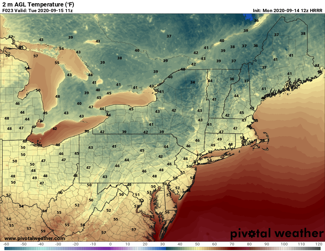
Comfortable temperatures for sure. Enjoy them for now because of course the trend will continue downward over the next 2 - 3 months. Moving along to the forecast, we have a great weather pattern for this week. A cold front will move through early Monday followed by high pressure as it locks in across the Northeast. And while it will warm up nicely Monday afternoon, temperatures will quickly fall Monday evening after the sun goes down. Overnight lows are expected to drop to their coolest readings since spring. Here is a look at forecasted temperatures for 7 AM Tuesday.

Courtesy Pivotal Weather
After the chilly start to our Tuesday, look for plenty of sunshine to help boost temperatures back into the upper 60s and low 70s for the afternoon. High pressure will keep the weather dry and quiet Wednesday and Thursday as temperatures slowly moderate. Afternoon highs on Thursday will likely push towards 80 degrees once again. Thursday night into Friday will offer the next chance for rainfall as a cold front approaches the I-95 corridor. Also, we'll be watching for some precipitation from the remnants of Sally to become "absorbed" into the front. Right now, it seems like the steadiest and heaviest rain will stay more towards the lower Mid-Atlantic and the Carolinas. Here is a look at the forecast rainfall this week through Friday evening.

Courtesy Pivotal Weather
OK, well that's it for now. Enjoy the quiet weather this week. Next weekend looks dry as well, but we may be talking about another decent shot of cool air. We'll have more on that in our next blog on Friday.