
There's been plenty of media attention given to the weather phenomena known as an "atmospheric river", which has caused torrential rainfall and excessive snow across California in years past. Today, we deicided to take a deeper dive into the science behind this atmospheric river, including what it is, where they occur, and the impacts that they commonly produce.
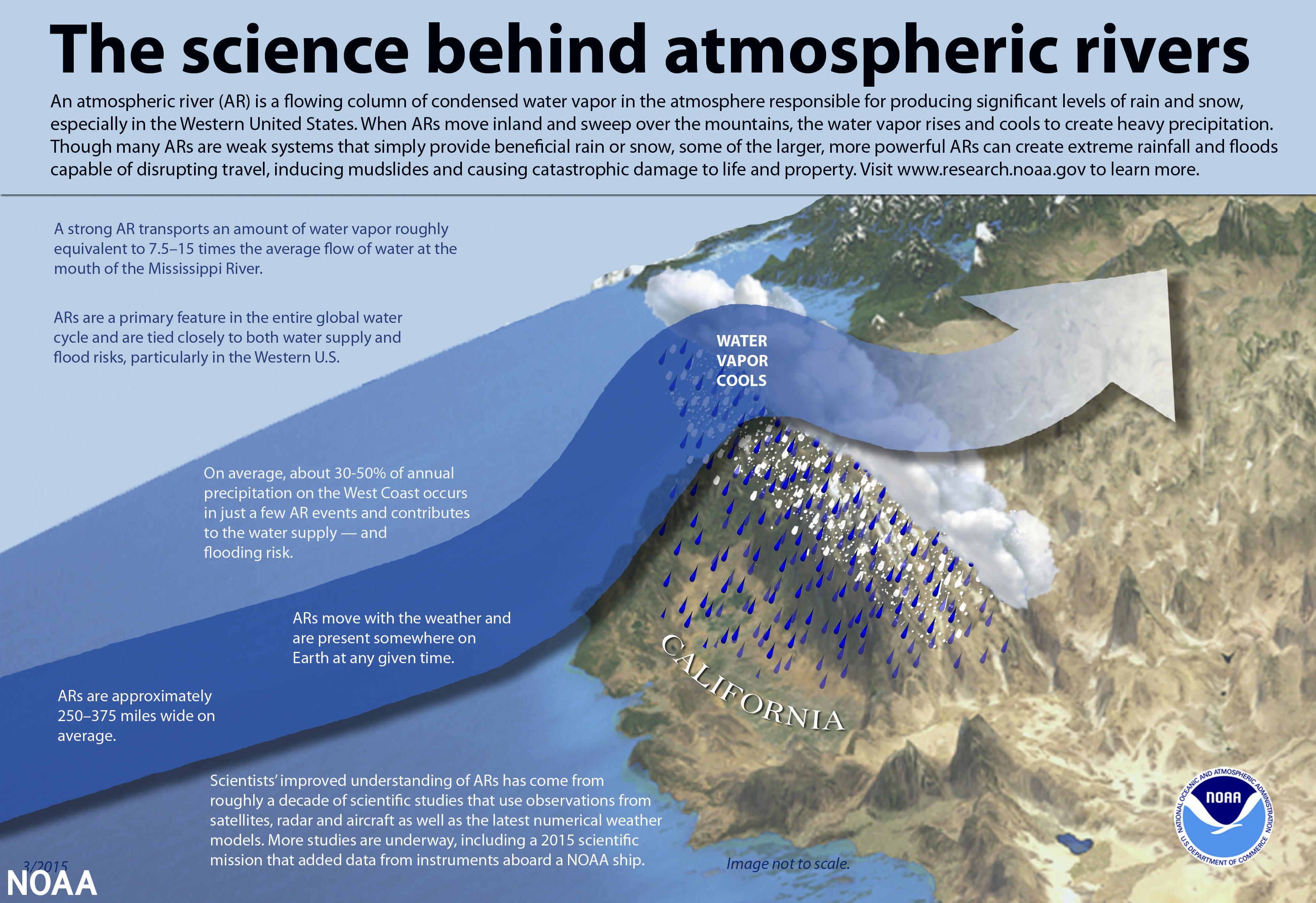
Atmospheric rivers (AR) are naturally occurring enhanced regions of wind in the lower atmosphere, commonly driven by the jet stream, that transport an immense amount of water vapor from the tropics to higher latitudes. Despite this looking like something brand new, it was actually first coined by Reginald Newell and Yong Zhu, researchers at the Massachusetts Institute of Technology in the early 1990s. Essentially, an atmospheric river can be thought of as a conveyor belt of moisture that is pumped into continental areas, thereby producing precipitation. Atmospheric rivers are massive in scope, generally spanning hundreds to thousands of miles in length and 250-375 miles in width on average. In addition, they get from their name in that they transport water vapor at a rate 7-15 times the average daily discharge of the Mississippi River (NOAA).
Another common term for this meteorological phenomena is a "pinneapple express" which is a type of atmospheric river that originates from Hawaii. Regarding the science behind the phenomena, as the moisture from an AR travels into continental regions it condenses and falls as precipitation. Within the context of California, the moisture associated with an AR is enhanced by the mountainous terrain of the Sierras and the Cascades as it rises up the windward sides of the terrain and falls as rain or snow. The moisture and precipitation associated with AR's can also be enhanced when occurring in conjunction with other meteorological features such as frontal low pressure systems.
Depiction of the science behind an atmospheric river. Source: NOAA
Atmospheric rivers are by no means uncommon, as they are always present across the globe. They also frequently occur on the East Coast, albeit generally weaker and shorter lived than those across the Pacific Northwest. In fact, generally about 30-50% of the annual precipitation across the Western Coast U.S. states such as California is associated with atmospheric river events. However, atmopsheric river events differ greatly by their strength and the resulting impacts that they produce, and while East Coast atmospheric river events are not all that uncommon it is the stronger and more prolonged AR events across the West Coast that generally garner the most media attention, produce the heaviest rainfall, and lead to the most significant impacts. Regarding their strength, much like the Saffir-Simpson scale for rating hurricanes, AR events are also rated from category 1 to category 5. A category 1 event corresponds to a weak event which is classified as "primarily beneficial" whereas a category 5 event is an exceptionally strong event that is classified as "primarily hazardous."
The impacts from AR events are wide ranging and can be both hazardous and beneficial as indicated by the rating system. The weaker events are especially beneficial in that they produce a good deal of rainfall which can help to alleviate drought-stricken regions, and in the case of a state such as California, increase snowpack and eventual water supply for the much drier spring and summer seasons. However, a persistent and strong AR event can be hazardous, create treacherous travel conditions, and can even pose a threat to life and property. Some of the adverse effects of AR's include repeated heavy rainfall and torrential downpours, which can lead to flash flooding and flooding of area rivers, strong hurricane force winds, increased wave heights, and coastal flooding / erosion. This flooding can also be exacerbated in wildfire affected areas as burned soil is unable to absorb the heavy rainfall, thereby leading to an increased runoff of the water, debris flows, and pollutants being carried downstream. Moreover, other secondary impacts from AR events across the moutainous terrain of the U.S. West Coast includes mudslides, landslides, and avalanches.
Current rain and snow falling in #NM is part of an Atmospheric River (AR) of moisture that stretches west beyond the International Dateline to near the Mariana Islands/Guam. #nmwx pic.twitter.com/teZ5aDNJKn
— NWS Albuquerque (@NWSAlbuquerque) January 15, 2023
Tweet showing a satellite image of the recent atmospheric river event across the U.S. West Coast. Source: NWS Albuquerque
With regards to the extreme weather across California in late December 2022, it can be attributed to a strong atmospheric river event which has brought a series of potent low pressure systems across the state, and has resulted in a prolonged stretch of very active weather. Albeit anomalous given the strength and persistence of this AR event, California and the Pacific Northwest is no stranger to atmospheric rivers, generally averaging dozens of AR events per year. Some of the impacts across California from this recent AR event have included strong storms which have brought hurricane force wind gusts in excess of 80-100 mph across the state, and coastal flooding / erosion which can be attributed to the large waves and rough surf whipped up by the relentless onslaught of storms coming ashore. Moreover, other impacts have included significant street / urban and river flooding as a result of the torrential downpours and the over 40 inches of rainfall that some places have seen in around three weeks. Incredibly, according to the California Geological Survey the state has also seen over 400 landslides since December 30th, 2022 with dangerous mudslides also a commonality. Consequently, across the state the storms have taken over a dozen lives and resulted in a great deal of property damage, displaced residents, water rescues, and evacuations. While this event has certainly wreaked havoc across the region and has undeniably done more harm than good, the one silver lining is all the rainfall that has fallen, which has alleviated the extreme and exceptional drought conditions that were ongoing across the state at the end of December. Meanwhile, across the Sierra Nevadas and the Cascades these storms have dumped an abundance of snowfall. This certainly will not be enough to fully overcome the drought shortages there, but it is a step in the right direction for a state that has commonly been drought stricken, and has faced below average precipitation and water shortages for years.
While this atmospheric river event is finally winding down with drier conditions settling back in across California, its impacts will certainly be felt and talked about for a long time to come.
View earlier from Spring Street in Santa Barbara. https://t.co/LrFth6leVm
— NWS Los Angeles (@NWSLosAngeles) January 10, 2023
NWS Los Angeles tweet showing street flooding in Santa Barbara, CA from heavy rainfall in the area on Mon Jan 9th, 2023.


