
After a cool, but dry Wednesday, the holiday looks to be rather active weather-wise across the Northeast and Mid-Atlantic as our next storm system arrives. Ahead of it, areas of drizzle and some light rain showers will overspread a good portion of the region today from southwest to northeast. However, locations farther north and east (Massachussets, Connecticut, Long Island, etc.) will likely remain dry through the daytime hours of our Christmas Eve. But, rain chances here will quickly ramp up tonight. Here's a look at the simulated radar reflectivity for 7 PM tonight from the Hi-Res NAM. Note the lack of widespread precipitation in the above mentioned areas.
 Courtesy of Pivotal Weather
Temperatures have been climbing since Midnight and will continue to do so through today and tonight. In fact, the high temperature for today will likely be recorded at 11:59 PM. But we'll get back to the temperature forecast in a minute.
As for precipitation, it will become steady from west to east later today and into this evening before turning heavy at times tonight. In addition rainfall, the wind will increase rather dramatically with frequent gusts of 40 - 60+ mph expected tonight through Christmas morning before slowly diminishing Christmas Day. Locally higher gusts are not ruled out, especially along the coast. This will be a high impact wind event and power outages/downed trees are anticipated across much of the Northeast and New England.
By Christmas morning, the cold front portion of the storm will be pushing eastward towards the coast. This will eventually take the rain with it, but it won't be until Christmas afternoon for it to eventually exit New England. Overall, from Christmas Eve through all of Christmas Day, a general 1.5 - 3" of rain is expected across the region, with locally higher amounts possible. Heavy rain will lead to flooding concerns from Boston all the way down to Washington, D.C. and especially in areas that still have a decent snowpack from last week's Nor'easter. Snowpacks only enhance flooding risks by blocking storm drains and by melting during rainfall, increasing total water amounts. Here is a look at the total amount of rainfall expected.
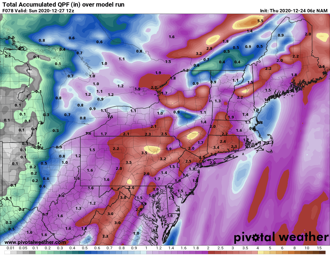
Courtesy Pivotal Weather
By 7 AM Christmas morning, temperatures will be in the 50s and 60s in the northeast, but will have already begun to plummet into the 30s in the Mid-Atlantic as the cold front fully passes though. Region to region across the Northeast and Mid-Atlantic will slowly but eventually see a dramatic drop in temperature to below freezing as the cold front fully tracks through and clears the coast. The time period in which this temperature drop occurs is early Christmas morning through the morning of the 26th. Here are the expected temperatures at 7 AM Christmas morning. Note that the leading edge of the cold air (Maryland, Delaware, eastern Pennsylvania) is the anticipated location of the surface cold front!

Courtesy Pivotal Weather
Now, compare that to the expected temperatures for 10 PM Christmas night. Note how the cold air has spread east (lower temperatures) after the front passes through the I-95 corridor.

Courtesy Pivotal Weather
If that all weren't enough, there is even the potential that there could be some flurries or isolated light snow showers on the backside of this system. This would largely be in areas farther west / in interior locations after the front passes through and cold air rushes in Christmas Day into Christmas night. So, maybe some will even see a brief "White Christmas" after all!
Saturday and Sunday then dry out as high pressure briefly settles back into the region. It will still be a tad breezy and rather chilly with temperatures across the region only in the upper 20s/low 30s on Saturday and in the mid-to-upper 30s/low 40s for Sunday.
Confidence is high that our next disturbance arrives from the west and moves through the region next Monday - Tuesday to start the work week. However, it is still a bit uncertain as to how this system will evolve and the potential associated wintry precipitation / impacts. Check back here on Monday for a forecast update.
Merry Christmas and Happy Holidays, everyone!


