Recently, we looked at the typical first snowfall dates in the Northeast and even the earliest measurable snowfalls on record in several cities along the I-95 corridor. As we head into December, flakes have flown, but many places have yet to see their first measurable snowfall in the 2023- 2024 season, which is typical this time of year. However, it had us thinking, just how early has it snowed in the Northeast? While we have touched on early season snowfall in the past, today we will take a much deeper dive into several early season wintry events across the Northeast, including some of the most impactful ones throughout history.
Snowstorms are typically hard to come by in late fall due to a variety of reasons, but mainly it's the lack of sufficient cold air and residual ground warmth. These two factors make it much harder for snow to stick, especially on paved surfaces. Additionally, for an early season event to pan out and be significant, it typically must occur during the nighttime hours and / or have very heavy snowfall rates (i.e., 1-2"+ per hour) to overcome the marginal temperatures and warm grounds. As such, snowfall during these months is usually confined to higher terrain areas across the interior Northeast such as the Poconos, Catskills, and Berkshire Mountains, and well away from the I-95 corridor. Nevertheless, there are plenty of exceptions to this when the autumn and winter seasons clash.

While extremely rare, even October can see accumulating snow. Over the past several decades three such snowfalls were memorable across the Northeast, including October 10th, 1979, October 4th, 1987, and a bit more recently, the infamous "Halloween Nor'easter" on October 29th - 30th, 2011. The storm in 1979 resulted as a strong low moved up the East Coast giving cities such as D.C., Philly, Hartford, and Boston their earliest ever measurable snowfall which still stands to this day! Amounts were generally light in the immediate cities, where coatings up to a few inches of snow fell, but were in excess of several inches in other spots. Meanwhile, the storm in 1987 brought heavy snowfall accumulations to the Berkshires and Catskills in New York and New England, where a dense accumulation of 1-2 feet fell! However, parts of the Hudson Valley also saw some surprise snowfall out of this system, particularly in and around the Capital District region where Albany recorded 6.5". This would go on to be Albany's earliest measurable snowfall of all time and contributed to the snowiest October in recorded history. Unfortunately, this storm caused many injuries and fatalities and given the extremely dense nature of the snow and still leafed trees, many trees fell. Power lines were downed which resulted in numerous outages and even property damage.
The last of the notable October events, the Nor'easter in 2011 was a blockbuster snowstorm that blanketed many Northeastern cities with a very heavy and dense snow leading to an ultra-rare "White Halloween." Areas northwest of the I-95 corridor saw several inches to up to a foot of snow, with as much as 2 feet falling across the higher terrain of New England! Once again, given the heavy nature of the snowfall weighing on leafed tree and the resultant gusty winds, this event was infamous for bringing down numerous trees and powerlines and causing prolonged outages. To make matters worse, this storm arrived just 2 months after damage caused by Irene and was given a Category 1 impact rating on the Northeast Snowfall Impact Scale (NESIS). For the record, the NESIS ratings range from Category 1 (least severe, "notable impact") to Category 5 (most severe, "extreme impact"), and that the scale is a function of the area affected by the storm, the amount of snow that falls, and the population within the storm's path (NOAA). If this storm shifted its heavy snow axis just a few miles east into the major cities, it most certainly would have rated much higher.
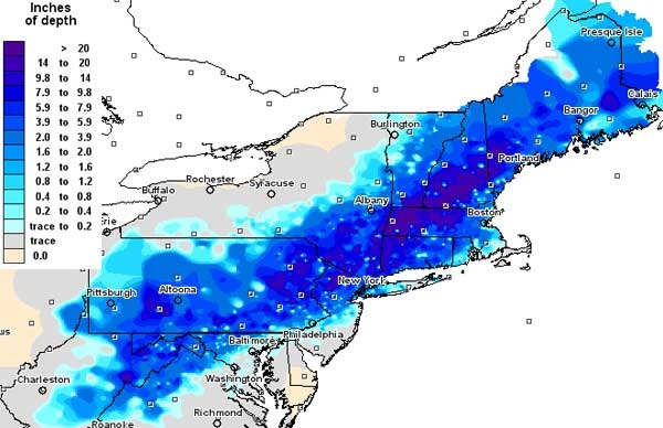 Snowfall totals from the October 29th, 2011 Nor'easter that blanketed parts of the East Coast. Source: NOAA and NWS
The month of November has also seen its fair share of early season snowstorms which has included three historic Thanksgiving events on November 24th - 25th, 1971, November 23rd, 1989, and November 26th - 27th, 2014. The Thanksgiving Snowstorm of 1971 was most impactful across the mountainous regions of New England where 1-2'+ of snow fell, which included an impressive 22.5" in Albany, NY making it the largest snowstorm ever seen in November! However, significant accumulations also occurred across other parts of the Hudson Valley, Massachusetts, and Connecticut with totals in excess of 6" falling in Poughkeepsie, NY and Hartford, CT. Given the heavy accumulations and delayed removal of the snow, this event created treacherous and chaotic holiday travel conditions, and consequently was given a NESIS Category 1 impact rating. Another Thanksgiving Day storm struck the Northeast in 1989 giving many along the Eastern Seaboard a white turkey day surprise. Amounts ranged from 4-5" from NYC to Boston, with Philly and Baltimore also ending up with a few inches. However, it was areas across Long Island that saw over a half foot out of this system with amounts over a foot across Cape Cod, MA. This event was significant in that it remains in the record books as being the snowiest Thanksgiving Day in recorded history for many cities from Boston to Baltimore. More recently, a Nor'easter in 2014 was also given a NESIS category 1 rating, and dropped up to a foot of snow across the higher terrain areas of New England and in and around Albany, NY. However, inland areas away from the 95 corridor also saw a decent helping of snow with 4-6"+ falling from Hartford, CT to Allentown, PA.
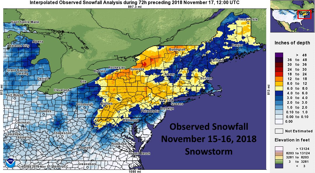
Other notable November systems included a Nor'easter on November 7th - 8th, 2012 which produced heavy, wet snowfall across New England and New Jersey where a few inches up to localized amounts in excess of a half foot fell, halting travel. This storm had increased impacts as many of the same areas ravaged by Hurricane Sandy a week prior were blanketed in snow, hindering recovery efforts. In addition to snow, direct impacts from this system included strong damaging winds, coastal flooding, and numerous downed trees and powerlines, causing additional power outages. Lastly, was the infamous November 15th - 16th, 2018 storm, also a Nor'easter, which produced a widespread swath of 6-8" of snowfall northwest of the I-95 corridor from the Mid-Atlantic to New England and led to some minor icing. This storm was especially memorable given the unbelievably heavy nature of the snow with snowfall rates of 2"+ per hour a common occurrence, causing numerous accidents and leaving evening commutes at a standstill.