
Ian's journey through the Caribbean and up toward Cuba had quite the favorable environment for tropical cyclone intensification. This consisted of very low vertical wind shear and anomalously warm sea surface temperatures, aka "bath water". This allowed for the storm to quickly organize after initially fighting some dry air as it approached the Cayman Islands and the western peninsula of Cuba. In the animation below using water vapor imagery, observe how the large envelope of broad, disorganized clouds and clusters of storms eventually consolidated into a healthy organized circulation upon a western Cuba landfall.

Ian Water Vapor Satellite Loop 9/25-9/27 - Courtesy University of Wisconsin - CIMSS
Ian's journey from a tropical storm to a Category 4 hurricane occurred all within a span of three days!! The inner-core and overall structure of the storm improved with every passing hour leading up to Western Cuba, in which rapid intensification occurred prompting an upgrade from a Category 2 to a Category 3. Despite passing over land, Ian maintained Category 3 status. In the animation displayed above, you can even see the eye of the hurricane open up just before landfall and actually remain visible as it crossed the peninsula before emerging over water.

Track of Ian from Tropical Depression to a Category 4 Hurricane - Courtesy of Wunderground
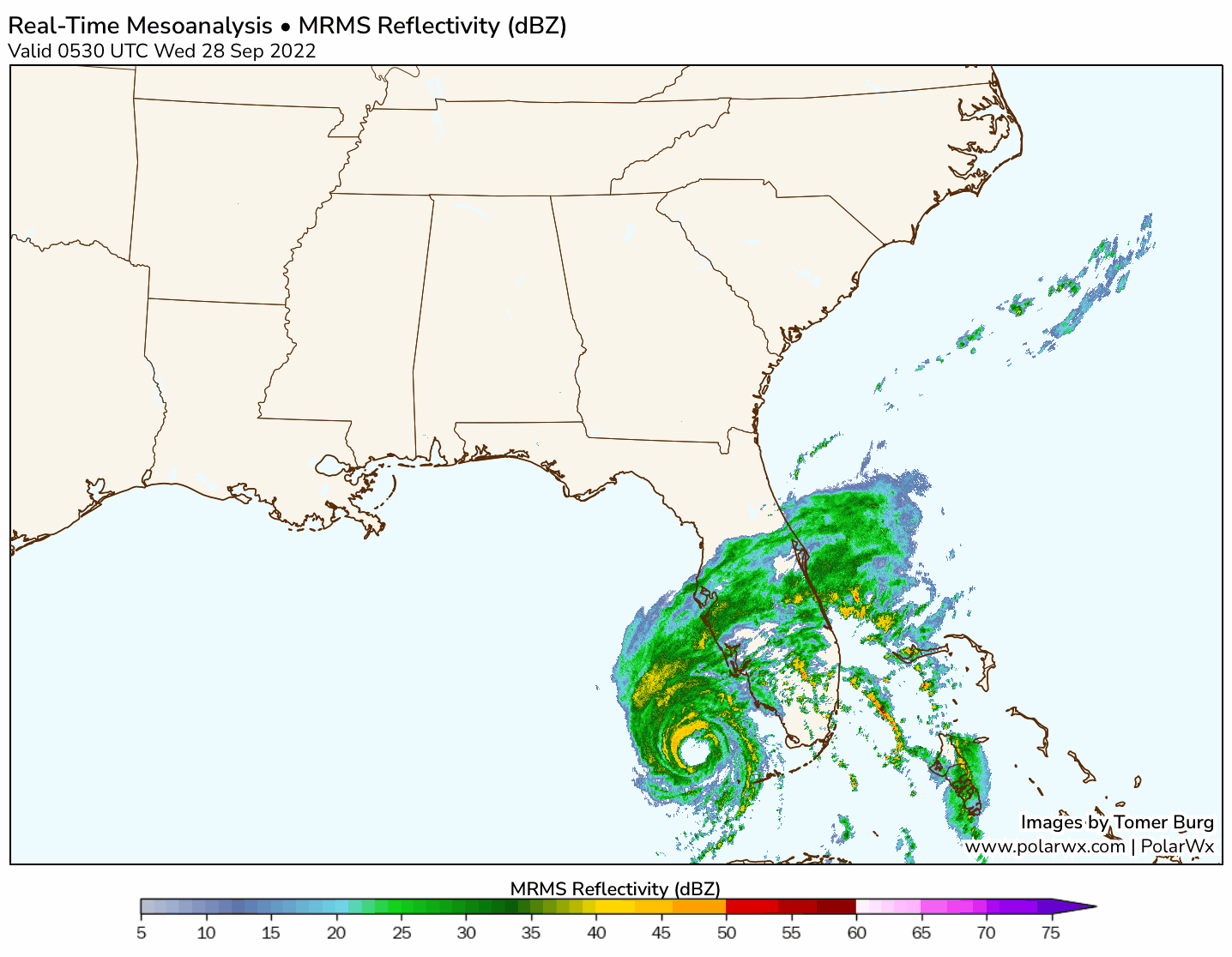
After it emerged back over water, a very interesting period of intensification occurred. With a continuation of very low wind shear and sea surface temperatures warmer than 30°C (hurricanes "like" around 28°C) in place, Ian had unimpeded conditions in front of it. From the animation below that takes place from late Tuesday and to near noon around Wednesday, you can clearly see two things; tightening and strengthening of the core, and an eyewall replacement cycle ("EWRC"). The last part is just fancy terminology that explains a unique process in strong hurricanes, in which the inner eyewall decays and falls apart. Then a new, secondary eyewall forms and in Ian's case, this new eyewall eventually contracted, replacing the original. As it does so, the entire hurricane not only gets stronger, but it grows larger as the energy now is distributed over a much larger distance all around. This has implications for all that are in its path because now the impending hazards are worse, making for catastrophic and devastating impacts. In this animated loop, there is a step-by-step process that occurs between Tuesday evening and early Wednesday morning. This GIF displays a graphic that represents 10 second flight-level winds with the time on left-hand side of the graphic (bottom-top) and radius on the bottom (right-left) with colors representing wind speed. In essence, watch how initially the inner-eyewall is very thin and feeble looking with a "moat" (area of sinking air and no precipitation) separating the original eyewall and the secondary, soon-to-be new eyewall. By Wednesday morning, notice how the darker colors emerge and even expand outward! This is exactly what happens with these eyewall replacement cycles, and the fact that this happened before landfall allowed Ian to actually intensify leading up to landfall. Typically, these cycles can weaken hurricanes, but Ian somehow managed to complete the process with unbelievable speed and intensifing thereafter.

Animated Radar Reflectivity of Ian - Tuesday PM thru Wednesday AM - Courtesy of NCEI and Image Credit: Tomer Burg
Revealing this unique process through time series (Tuesday night into Wednesday) of aircraft recon data is another way to visualize the process looking at it from a 2-D perspective. The graphics below show a relationship between pressure and wind, but this is coming from hurricane hunter aircraft as they drop instruments into the hurricane and collect data. The only thing to pay attention to is just the blue line which represents flight-level winds. From left to right is time so the farther to the right, the more recent the time. This progression shows how the original eyewall began to weaken with a secondary eyewall beginning to form revealed by those two peaks emerging outside of the main eyewall (where the inverted V is represents the eye!). Then in the last frame, the secondary eyewall, now has taken over as the main eyewall.
Textbook progression of an eyewall replacement cycle in aircraft data from Hurricane #Ian today.
— Dr. Levi Cowan (@TropicalTidbits) September 28, 2022
Over the last 12 hours, we've seen the emergence of a secondary eyewall (pink markers) in wind traces, initially weak (top), then becoming dominant over the inner eyewall (bottom): pic.twitter.com/x1UtuVixi6
Recon Aircraft Observations for Hurricane Ian - Courtesy Twitter & Dr. Levi Cowan
From this process and up until landfall, numerous outstanding observations transpired from the storm's intensification to its widespread, devastating impacts. First, the cloud tops "cooled" significantly, which generally implies that the strong thunderstorms are growing rapidly and high into the atmosphere an indication of strengthening. Also, there is an expanding central cirrus cloud shield of the hurricane (notice how the greens race northward, which is an indication the hurricane is being "vented" aloft and another sign of a maturing hurricane). Not to mention, mesovorticies (outlined in white) rotated around the inner eyewall. The last point (which is a very unique component to some of the stronger hurricanes) can enhance hurricane-force wind gusts in general and compound any damage that may have occurred. While they're still a bit of a mystery of why they occur, one thing is certain, when these occur, you know the hurricane is very intense!


Wednesday Morning Infrared Satellite Imagery of Ian (Top) & Radar Reflectivity (Bottom) - Courtesy College Of Dupage
One other interesting aspect of Ian as it paralleled Florida's west coast was the fact that it provided thousands of lightning strikes within the eyewall. This is something that you typically see only in the upper echelon of tropical cyclones. What made this profound was the sheer amount of lightning strikes seen with this hurricane, which is abnormal when compared to other Category 4 hurricanes.
#Ian is now at 155 mph and has the most electric eyewall I have seen in a Gulf of Mexico hurricane. This is more eyewall #lightning than Michael or Laura. The forecast has this storm larger and stronger than Charley at landfall. My thoughts are with the people of Southwest #FLwx. pic.twitter.com/MiNk1tUuUU
— Chris Vagasky (@COweatherman) September 28, 2022
Meteorologist and Expert Chris Vagasky - Courtesy Twitter
According to the National Hurricane Center, Ian officially made landfall as Category 4 at Cayo Costa, Florida around 3:05 p.m. EDT. Below shows a loop from when Ian strengthened up to landfall, and slowly weakened as it trekked further inland. What makes this track even more extraordinary is that it closely resembles the track of Hurricane Charley (2004). Another remarkable statistic is that Ian, after undergoing the eyewall replacement process, intensified by over 30 knots within 12 hours, which is quite impressive.

MRMS Reflectivity loop Wednesday (Top) & Side-by-Side comparison of Ian (Left) and Charley (Right)
Courtesy of Polar Wx, National Weather Service
On that note, Ian has placed itself in the top 5 for one of the strongest tropical cyclones to ever hit Florida, tying Hurricane Charley (2004) in terms of impact by sustained wind. Not only that, but Ian may go down as the costliest natural disaster to hit Florida as well. Currently Irma (2017) holds this dubious distinction. Also, the name Ian will likely even be retired after the Atlantic hurricane season ends on November 30th.

Top 10 Ranked Major Hurricanes By Wind Upon Landfall - Courtesy Dr. Philip Klotzbach
Upon approaching landfall, Ian provided an onslaught of catastrophic damage caused by destructive wind gusts and record storm surge which caused water to reach the roofs of homes and result in widespread flooding. Here are just several remarkable observed statistics (gathered via mesonet, ASOS, NWS, and Social Media):
- In Naples, observed water levels rose nearly two feet over the most previous recorded value (4.25 feet) set from Irma back in 2017. The new record now sits at 6.18 feet.
- In Fort Myers, the previous high weter mark was smashed with an astounding 5.96 foot water level.
- Over a 130 mile stretch, storm surge exceeded 6 feet from the Everglades to Venice, FL.
- Wind gusts over 100 mph were observed in several locations: Punta Gorda (135 mph), Sarasota (106 mph), Port Charlotte (110 mph), Cape Coral (140 mph), Grove City (110 mph), Southwest Florida International Airport (110 mph), and Venice Beach (104 mph).
- Several areas saw rainfall amounts totaling over one foot, especially north and west of where Ian tracked. In the hardest hit areas, some of observed rainfall totals include:
Placida, Fl - over 15 inches within a 12 hours
Lake Wales - nearly 17'' within 24 hours
Winter Park - 12'' in 12 hours
North Port - 14" in 12 hours
Myakka City - 14'' in 12 hours
These are just some of the stats observed with some pretty incredible rates. In addition, below is the NWS observed rainfall ending 7 PM EST Wednesday. One can make out the hardest hit areas, which occurred just to the north and west of Ian's path.


Total Rainfall Accumulation (Top) & Predicted Storm Surge Prior To Impact (Bottom) - Courtesy NOAA
Ian didn't just stop after ravaging Florida. While it was downgraded to a Tropical Storm, it trekked from Cape Coral up to Palm Bay, before exiting off Merritt Island, Fl. Once again over open waters, it didn't take long for Ian to intensify back to a hurricane late on September 29th. Less than 24 hours later it made a second U.S. landfall as a Category 1 near Georgetown, SC with maximum sustained winds of 85 mph. It produced another storm surge (but no where near what happened in FL), flooding, and hurricane-force winds from the coast of GA up to NC. It finally weakened to a post-tropical system late on September 30th. However, its remnants produced gusty winds, coastal flooding, and heavy rainfall into the Mid-Atlantic and eventually the Northeast for the first weekend of October.

Track of Ian Through Florida and into South Carolina- Courtesy Wunderground
There certainly is much more to unpack regarding the "life span" of Ian as this storm will be studied for years to come. Above are just some observations that stand out, which have left many questioning how Ian was capable of intensifying so quickly with such a unique track from Cuba. Unfortunately, the impacts are truly catastrophic and the devastation it left behind won't soon be forgotten. Despite the relatively "quiet" Atlantic Hurricane season thus far, this example is a reminder that it only takes one storm to change the narrative. Always be prepared and never let your guard down!


