
Radar is quite possibly the most sophisticated weather data available to everyone and is widely understood throughout the population. For the most part, we all know the colors mean precipitation, with ‘warmer’ colors like yellow and red indicatting heavier rain in the summertime. However, what happens when the radar shows things popping up with no precipitation falling? This is something meteorologists run into on any given day, because weather radar is so sensitive that it can detect any sort of substance in the air.
Below, we've listed some of the most common radar anomalies that can be deteced across the U.S, accompanied by some image examples:
Yes, you read that correctly. The pulses of energy that the radar emits are so sensitive, that something as small as a grain of dust or an insect will cause a return show on the radar. However, this anomaly can be extremely useful for meteorological purposes. Winds from a sea breeze, or the outflow boundary of a storm, will usally show up as a line or bowing arch, due to the uniform scattering of small particulates from the wind. This provides meteorologists with the exact location of a gust front or sea breeze.
.jpg)
Since dust can be detected by radar, it also makes sense that smoke particles can be detected as well. A large fire, like a wildfire or an explosion, will cause a smoke plume that can be identified by the radar and even be tracked. This was especially evident during a fire on the Seaside Heights, NJ boardwalk in September of 2013 and from the exhuast of NASA’s Antares rocket on October 28, 2014. Both events are pictured below
.png)
.jpg)
Another interesting anomaly that you can detect from radar are "roost rings. No, they aren't a glitch and caused by alients. This radar return appears like a explosion or donut shape of color pushing outward from a central point and are typically seen in the late Summer and early Fall months near sunrise. They are nothing dangerous, but just the radar detecting thousads of migratory birds flying all at once from a central roosting location.

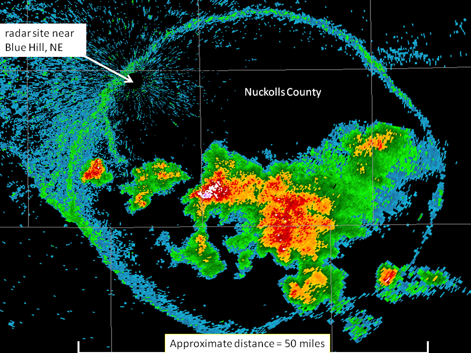
Finally, our last radar oddity can only be seen twice a day: during sunrise or sunset. This anomaly may seem like another radar "glitch" but it actually occurs when the sun’s rays are directly in the path of the radar beam. And this phenomenon only can occur when the sun is lowest in the sky. Since the sun emits energy that the radar can detect, the image shows up as a ‘spike’ of colors directed straight in the direction of the sunrise or sunset.


