
After a fantastic Memorial Day across the Northeast, the weather will stay dry and warm through at least midweek as a ridge of high pressure remains in control. Hard to believe that just about 3 weeks ago we were still dealing with snow showers across the region as winter just wouldn't let go. However, we finally have "turned the corner" and summer is now right down the road. Before we get into the forecast for this week, let's check out the average temperatures along the I-95 corridor for this time of the year in late May.
| Average High | Average Low | |
| Boston | 70 | 54 |
| Hartford | 75 | 51 |
| New York City | 74 | 58 |
| Philadelphia | 78 | 58 |
| Baltimore | 77 | 56 |
| Washington, DC | 79 | 60 |
Nice to see the average high temperature now in the 70s, even getting close to 80 in the Nation's Capital. While Tuesday and Wednesday will likely be the warmest days of this week, temperatures will stay close to seasonal averages on Thursday and Friday. Here is a look at forecasted temperatures for 2 PM Wednesday by the short range HRRR model.

Courtesy Pivotal Weather
Just take a look at some of those locations in upstate New York! A high temperature near 90 degrees is expected in Albany tomorrow afternoon while areas around Boston will be in the mid to upper 80s.
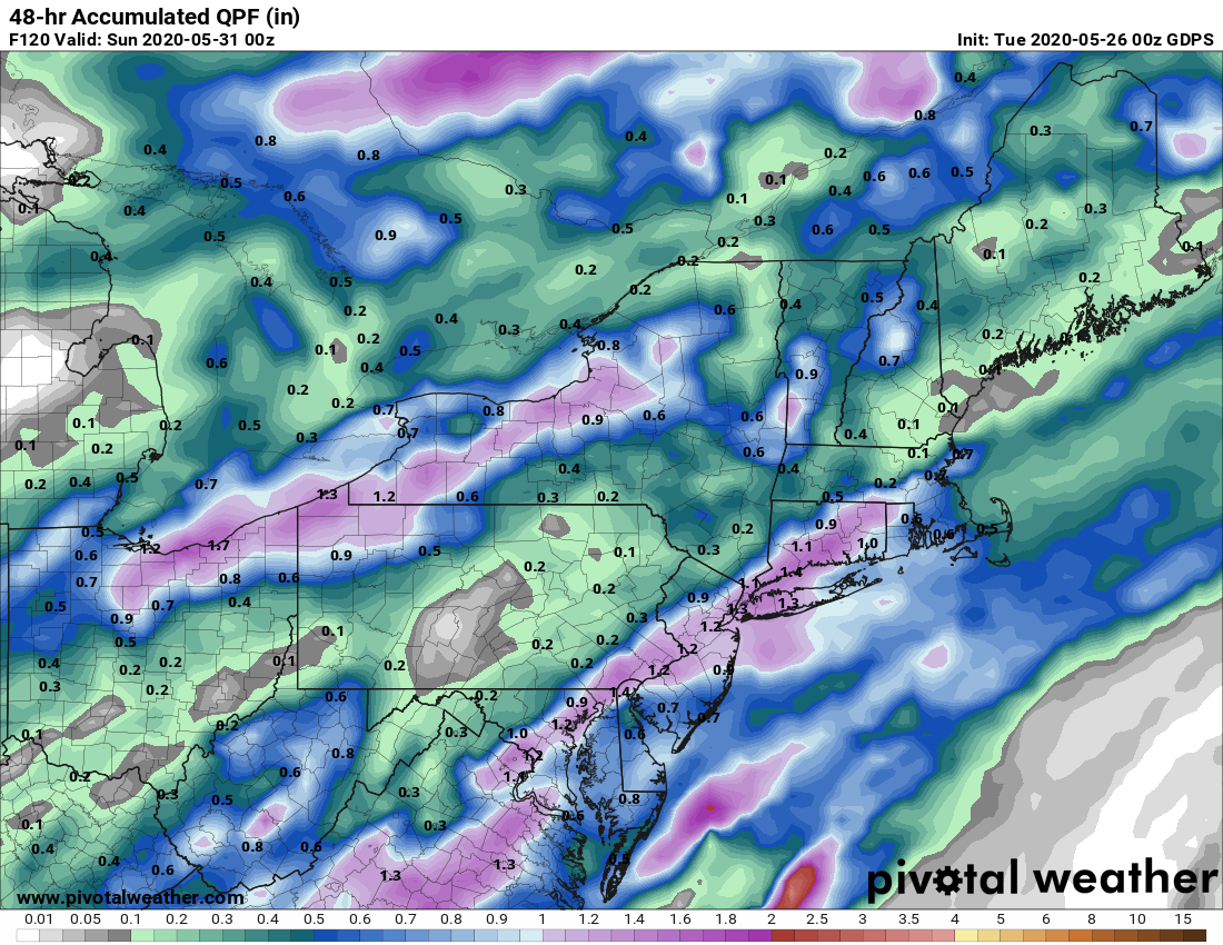
Beyond Wednesday, our ridge of high pressure begins to break down on Thursday. This will allow for a fair amount of clouds and even some showers become possible, especially Thursday afternoon. However, despite the cloud cover and risk for rain, high temperatures will still manage to climb into the 70s. Rain chances do increase Friday and Saturday as a cold front slides towards the Northeast. At the same time, some tropical moisture will surge northward along the East Coast. There still seem to be some uncertainties as to how the two systems interact, but either way, it looks like it will be an unsettled finish to the work week and start of the last weekend of May. Here's a look at the potential total rainfall for Friday and Saturday from the Canadian Model.

Courtesy Pivotal Weather
We'll continue to monitor how things evolve for the end of the week. Look for some updates on Facebook and Twitter over the next few days. Until then, enjoy the dry, warm weather as we get ready for summer !!