
Fiona became a tropical storm and got a name late on September 14th...now it's a major hurricane north of Bermuda with tropical storm-force conditions that expand outward over 100 miles. It has stuck around for over a week and has produced catastrophic flooding and damaging wind gusts to Puerto Rico, the Virgin Islands, Turks and Caicos, and eastern portions of the Dominican Republic. Lets journey through its life cycle from tropical depression to major hurricane status using infrared satelitte imagery to show its evolution through the Windward Islands, Lesser Antilles, and into the Western Atlantic.

Fiona Satellite Loop 9/14 - 9/22 - Courtesy University of Wisconsin - CIMSS
As it approached Puerto Rico on Sunday, September 18th, the storm was upgraded from a Tropical Storm to a Category 1 hurricane. Hurricane-force wind gusts reached up to 85 mph and for the next 24 hours, intense outer rainbands (coined as "feeder bands") in combination with upslope flow (enhances and exacerbates precipitation) sat over the island, even after making landfall. Not to mention, the forward-speed slowed down immensely, and this led to a devastating situation. Up to 30" of rain fell across the eastern/southern shore of Puerto Rico and this resulted in devastating flooding and damage. What's more, nearly 90% of the island lost power, compounding an already ravaged region.

Preliminary Total Rainfall Accumulain 9/16 - 9/20 - Courtesy San Juan, PR NWS
The very next day, Category 1 Fiona made landfall on the southeastern shore of the Dominican Republic bringing with it more rainfall with storm totals up to 20", life-threatening flash flooding, and wind gusts greater than 100 mph. As it traveled toward Turks and Caicos, Fiona was again upgraded to a Category 2 for only a few hours before strengthening into then a Category 3 hurricane !! As it approached the Turks and Caicos Islands, it developed a clear, distinct "eye". This feature is notorious with strong, major hurricanes as it's coined as the "stadium effect". The latter essentially implies a well developed, maturing tropical cyclone with intense air rising around its center (the eye-wall), and subsequently intense sinking air in the middle. This reflects as a cloudless region due to that intense dry, sinking air that makes it literally look like a sports stadium.

Hurricane Fiona - Courtesy Twitter & Meteorologist Andrew Moore
Just a few days ago (this past Wednesday, September 21st), Fiona became a Category 4, which is not only the first of the 2022 Atlantic Hurricane season, but the most intense so far this year. For almost two days, Fiona sustained a Category 4 status and its central pressure reading got down to 932 mb, which according to hurricane expert Dr. Klotzbach, it's the strongest pressure reading for a hurricane outside of the tropics in satellite era.

Hurricane Fiona - Courtesy Twitter & Meteorolgist Phillip Klotzbach
Fortunately, Fiona evaded Bermuda in terms of direct impact, but did impact the island with waves greater than 40 feet and tropical storm force winds. So, where is Fiona headed next? The hurricane will trek toward the north/northeast over the next 48 hours while accelerating toward Nova Scotia. What will make this journey unique is that a powerful and dynamic process will take place this weekend as Fiona transitions from a tropical cyclone into an extra-tropical cyclone. This process diminishes tropical characterstics and because of an increase in latitude with a baroclinic (i.e. temperature gradients) environment up ahead, a meteorological spectacle transpires !! A strong trough is forecast to dig down and "scoop" Fiona, while creating the transition and as it does so, the wind field expands substantially outward. Not only will hurricane-force winds impact Nova Scotia and Atlantic Canada, but coastal flooding and heavy rainfall will further compound the hazards. The barometric pressure expected for Nova Scotia when the cyclone makes landfall will likely set an all-time record in terms of lowest recorded mean sea level pressure !!


ECMWF 500mb Geopotential Heights valid 9/23 - 9/25 & Normalized SLP Anomaly (Courtesy of WeatherBell)
Above, you'll notice the interaction has already started with the large-scale trough and soon Fiona will acquire and develop fronts as it interacts with temperature gradients - something that is not seen in the tropics. By early next week, it'll finally dissipate once it reaches the Labrador Sea. It'll be quite the dynamic creation this weekend, showcasing an unbelievable display on satellite imagery soon enough.
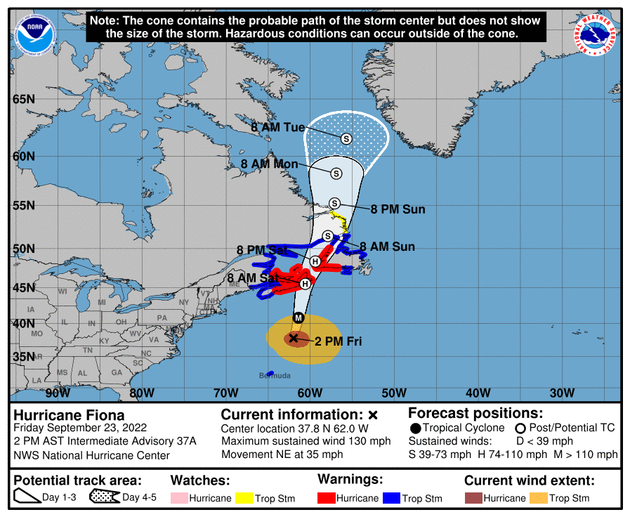
National Hurricane Center Forecast Cone - 11 AM September 23rd
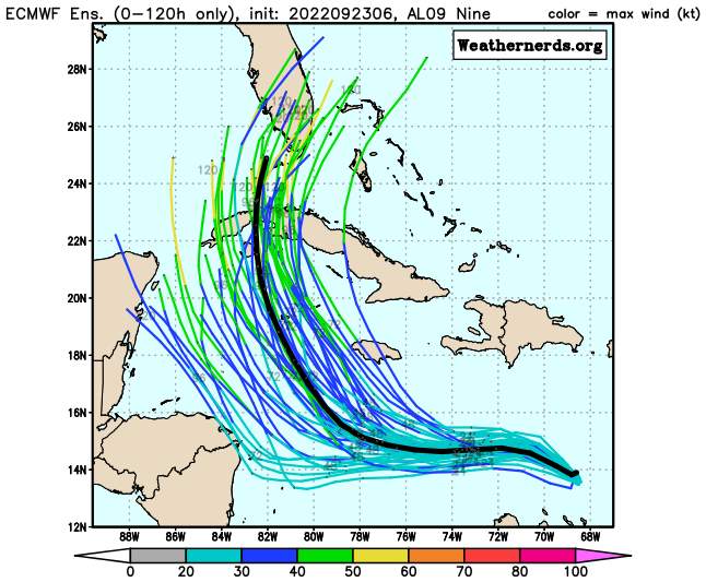
Now, onto the next tropical threat that is going to be most discussed, especially since it may be a legitimate threat to the U.S. mainland. Currently we have Tropical Depression 9, which is expected to be upgraded to a Tropical Storm by this weekend. And while, it's facing strong northeasterly shear as shown via visible satellite imagery, one can pick out the low level circulation displaced from the convection to the southwest.

Courtesy of Weathernerds.org
Below displays the main steering "mechanisms" of what will influence the eventual tropical cyclone (likely to be named Ian). The biggest concern with the development of TD #9 and a soon-to-be-named tropical storm, is that low wind shear and very warm sea surface temperatures await its arrival. It will exploit the surrounding environment and likely intensify into a hurricane by early next week. However, there are still uncertainties regarding its future for next week. What is most glarring, is a deep trough that'll shift into the central and southern U.S., imparting also a steering flow and dry air, along with wind shear. If this tropical cyclone does emerge into the Gulf by next week after passing somewhere in the vicinity of western Cuba or near the Yucatan even, it still has impediments and obstacles ahead that is too soon talk about. For now, it's expected that over the next 48 - 72 hours, intensification is pretty much a guarantee.


ECMWF 850mb-250mb Wind Shear Courtesy of WeatherBell & GFS Oceanic Heat Content - Courtesy of PolarWx (Tomer Burg)
There are still uncertainties pertaining to the track and eventual strength of this next system and both will lend to a wide range of solutions. Here is a look at what may happen over the weekend.

ECMWF Ensemble (Left) & GEFS Ensemble (Right) - Courtesy of Weathernerds
Here is the National Hurricane Center's most recent advisory and cone of uncertainty as of 11:00 AM September 23rd. As of right now, anywhere from the eastern Gulf Coast to Florida is within that path, which is becoming more of an alert as we head into this weekend. Hurricane preparations and plans should be reviewed, as it's always encouraged to be proactive when it comes to potential natural disasters.

September 23rd National Hurricane Forecast - Courtesy of Tomer Burg
Lastly, here is a nice display that reveals multiple global models utilized in an ensemble package that helps garner more confidence regarding uncertanties. It isn't until after the cyclone passes Cuba where the greatest uncertainty lies denoted by the enlarging ellipse of potential tracks. It also should be mentioned that interests along the Eastern Seaboard should monitor this as after a potential landfall - that's a big IF - it could continue tracking close to the East Coast later next week.

Super ensemble plot (0z September 23rd) - Courtesy of Tomer Burg
The Atlantic Season may of have started slow, but it has picked up steam over the last two weeks and we're still within the crux of the main active period !! Meteorologists in the coming days will be monitoring this next likely hurricane, as concerns and alerts have certainly elevated.


