It's no surprise that 2025 has become the year of flooding events, with the National Weather Service issuing over 3,400 Flash Flood Warnings through July of this year alone. That's the most amount of warnings issued in a year since the 1980s. Some of that can be attributed to an increase in technology/warning capabilities and more advanced forecasting methods. While we won't go into details on why they are increasing, we'll be discussing why these events seem to develop "out of nowhere" and catch people off-guard, along with breaking down how they develop and what you can do to stay safe!
But first, let's take a look at what a Flash Flood is defined to be...
Per the National Weather Service, Flash Flooding occurs within 6 hours and many times within 3 hours of heavy rainfall. It's also no surprise that these events catch people off-guard, as the name itself gives it away. "Flash", in the context of flooding, is defined by Merriam-Webster's dictionary to describe a "rush" or "dash", appearing suddenly and moving with great speed.
So Flash Flooding describes an excess of rain in a short amount of time, causing water to rush in or pool up in an area, which can easily catch people off-guard. This is especially true for those in rural areas and areas across the country that lack early flood warning infrastructure. While there are numerous kinds of flooding events, we'll stick to just two main types during flash flooding:
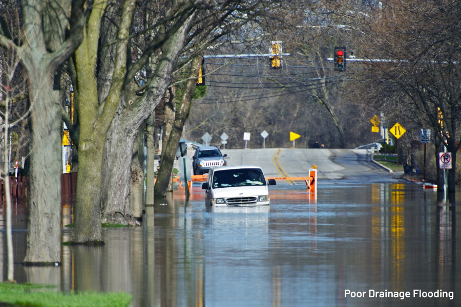
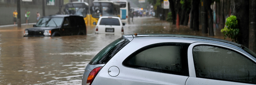
- This type of flash flooding occurs in more urbanized and built up areas. It's also the most common form of flooding in populated city centers across the United States. It occurs when rain accumulates faster than the rate at which roads and drainage systems can drain them. This results in excess runoff and pooling of water. This becomes an issue in urban areas and especially in low lying spots where water can collect easily. Leaf and snow clogged drains in colder months can also produce poor drainage flooding, despite a lack of thunderstorms or torrential rain.
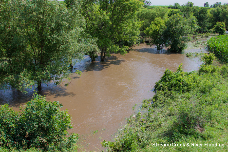
- This type of flash flooding does not require built up/urbanized areas in order for it to be problematic. Rather, heavy rain falls over a short period of time, creating excessive runoff that funnels into streams and creeks, causing sharp rises and spillage. The severity of this kind of flooding is largely tied to the initial conditions, but other factors such as soil types. Surplus rainfall leading up to the flash flooding event keeps grounds quite saturated and poor at absorbing water, as well as causing waterways to already run higher than normal.
Despite these two different types, they can actually work hand in hand, exacerbating the severity of one another. For example: Poor drainage flooding in an urbanized area can result in more runoff entering nearby streams and creeks. Likewise, stream and creek flooding in built up areas can spill over and cause a back-up of storm drains, enhancing the poor drainage flooding.
Flash flooding can occur at almost any time of the year and even be caused by non-thunderstorm factors such as dam failures and ice jams. However, they have a higher risk of developing during the spring and summer time months. But why? And how can they get to significant and even catastrophic levels? Let's take a look at some factors that go into setting up these significant flooding events:
A key component in receiving torrential downpours and high rainfall rates is the amount of water the air can hold. Essentially, think of the atmosphere like a sponge: In high humid and tropical enviornments, the atmosphere is able to hold much more moisture/water. We measure the atmosphere's water holding capabilities by a variable known as "Precipitable Water"(PW). Any PW values over 1.7" are considered quite high, but in more significant flooding events, these can be upwards of 2.0" or more. You can visualize an example of high PW below, denoted by the darker purples and pinks.
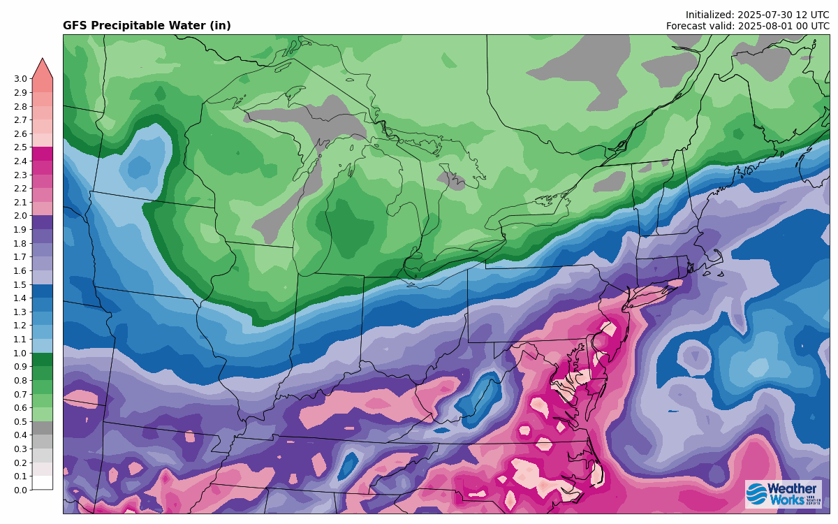 An Example of High Precipitable Water Values (Measured in inches)
To get storms and heavy rain, you not only need moisture and instability, but also a mechanism to "force" them to form. This can be in the form of surface convergence (where different wind directions near the surface converge over an area), or from an incoming storm system/frontal boundary. When these frontal boundaries slow down, they can lead to more widespread and longer lasting rainfall.
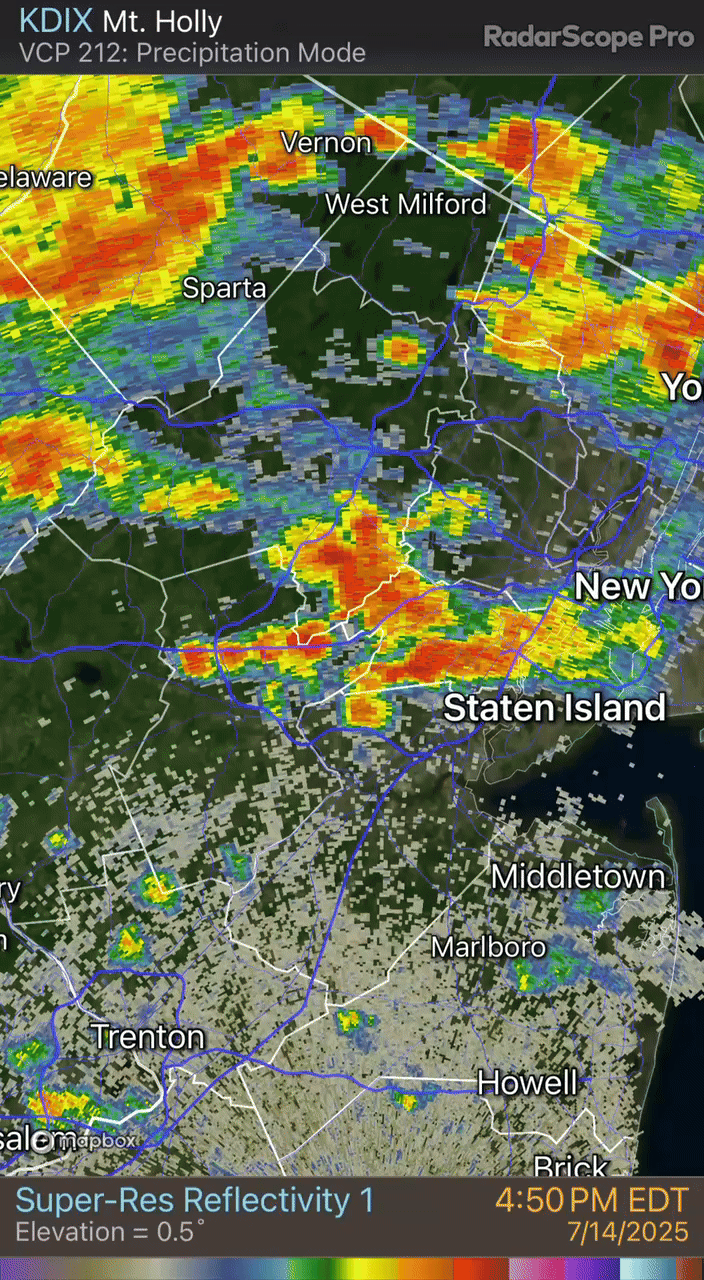
We're not talking about your trip to the gym with these terms. They refer to development of slow moving thunderstorms over a certain area in flash flooding events. When winds are weak at the surface, storms tend to slow to a crawl, hence they "train" downpours over the same area. Back-building storms are similar, however insetad of the same storm staying over the same area, they weaken and redevelop. In a sense they are "building" back into the same area like a firehose, producing multiple rounds of heavy rain and downpours. There are only slight differences between them, but ultimately they produce the same kind of flooding effects.
You can see an example of what back building storms and downpours looks like on radar below. This particular example comes from a flash flooding event on July 14th, 2025. Parts of Central and Northern NJ saw localized 4-7" of rain in just a few hours, leading to significant roadway flooding and numerous water rescues.

So we've gone over the intricacies of flash flooding; why it forms and how it forms. But what should you be aware of in order to stay safe and proactive when there is a potential for flash flooding? Here are some steps to stay safe:
- Know your Risk to Flooding: If you are in a highly urbanized area or a low lying spot that is prone to flooding, you should understand the risks that come with flooding and how to protect your livelihood and property.
- Stay Aware of the Forecast: With so much information out there, it's important to find a source you trust. Forecasts can change, so make sure you have a way to get up to date information and the ability to receive warnings when floods become imminent or even significant.
- Have an Emergency Kit/Plan Ready: If you're in an area that may get cut off for days after a flooding event, it's important to have a kit ready with food, water, medicine, batteries and some form of device for communication.
- Adjust your Daytime Plans: It may not be ideal, but depending on timing of rain, it may be wise to adjust your outdoor plans and avoid peak flooding. When floods occur during rush hour, it becomes highly problematic with stranded cars and water rescues when everyone is driving at the same time.
- Avoid Flooded Roads during Peak Flooding: You've heard of the saying "Turn around, and don't drown" when encountering flooded roads. It sounds cheesy, but sometimes you don't know how deep that water can be. It only takes a foot of flowing water to carry away a small car. If possible, avoid all travel. If this is impossible, find alternate routes around flooded areas. It increases commute time, but it will keep you and your vehicle safe.
While we discussed all the mechanisms for flash flooding above. However, there are other ways for places to flood (like Dam breeches, storm surge, ice jams etc). It all depends on your risk factor and the location you live in. Sometimes, even just knowing there is the threat for a flood is not enough, as was the case with the tragic 2025 July flood in Texas. You can learn more about what happened and why Early Warning flood detection is a much from our Flood Safety Experts at AEM Here.


