
Low pressure originally off the coast of Long Island will continue to push further north and east through New England this Friday afternoon. As it exits, scattered showers and areas of drizzle will diminish (last in locations farthest north). This will result in a mix of sun and clouds for the rest of the Northeast and likely a dry finish to the work week .
Humidity and cloud cover then increase Friday night as winds off the Atlantic continue to push moisture inland. With this increased moisture also comes the risk for areas of fog and even some drizzle, developing primarily towards and through the predawn. Either way, any potential precipitation that does fall will be rather light. Temperatures Friday night are expected to be in the low-to-mid 60s farther north, and in the low-to-mid 70s farther south.
To kick off the weekend, expect clouds as well as some areas of fog and drizzle/mist to persist through Saturday morning. This eventually "burns off" by afternoon and breaks to some sun and rather warm and humid conditions. High temperatures on Saturday are expected to reach the mid-to-upper 80s across the region (though a few degrees cooler along the coast). And with dewpoints continuing to climb through the upper 60s to low 70s, it will feel rather sticky and uncomfortable out there.
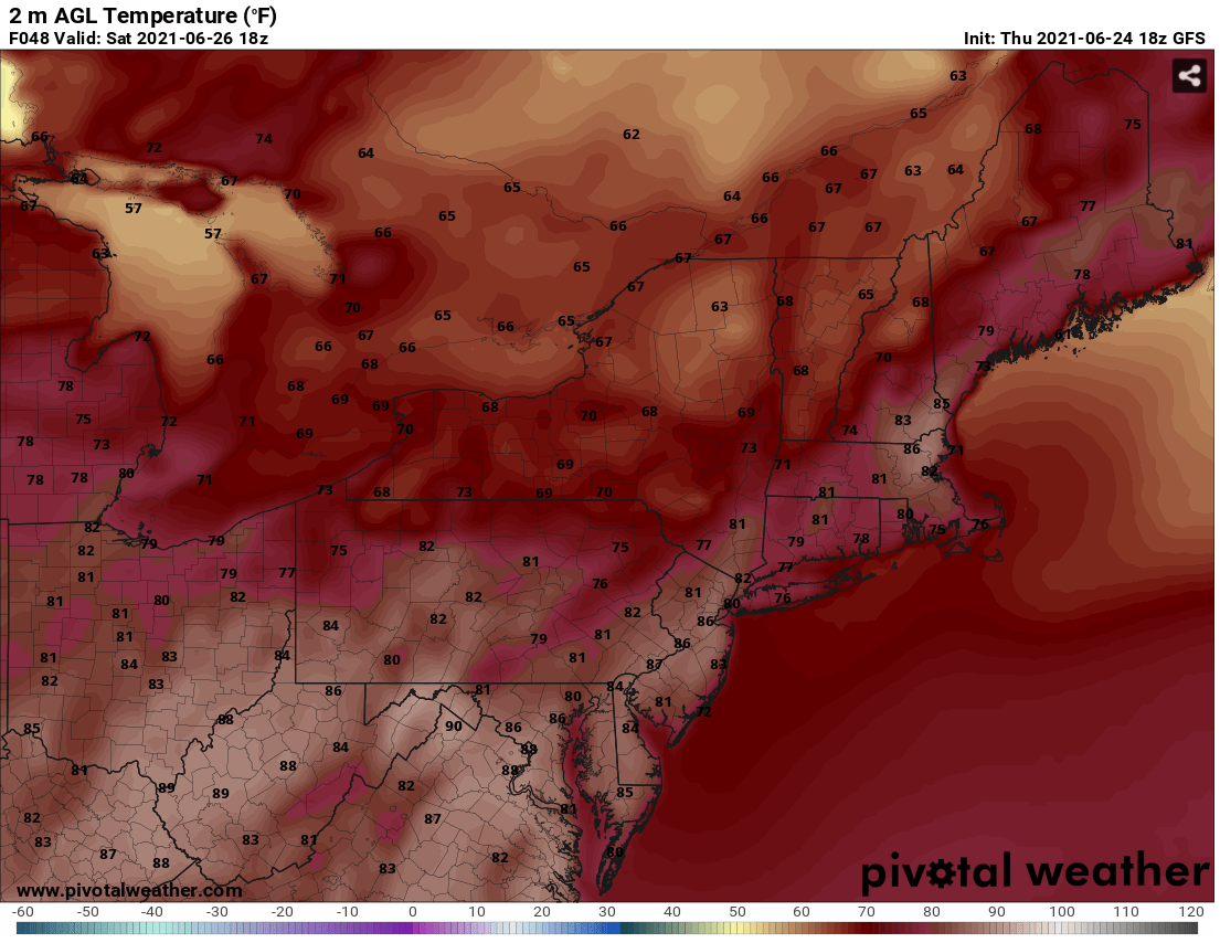

Expected temperatures (GFS, top) and dewpoints (Hi-Res NAM, bottom) for 2 PM Saturday - Courtesy Pivotal Weather
While more likely than not to hold dry through the remainder of the day Saturday, the rise in heat and humidity also brings the returning risk of an isolated pop-up shower or storm during the afternoon and evening hours across the Northeast and the Mid-Atlantic. Though, any potential activity looks to be brief at this point and shouldn't disrupt outdoor plans for an extended period of time.
Following a muggy Saturday night with a few areas of fog/drizzle again, the heat and humidity will persist for Sunday as high pressure continues to build east of our region. And while Sunday afternoon and evening (in similarity with Saturday) seem to remain primarily rain free, the slight risk for a pop-up style shower/storm or two continues (favoring the Mid-Atlantic). However, the bigger story on Sunday will be the temperatures as afternoon highs reach the upper 80s to low 90s. This, combined with continued dew points in the upper 60s to low 70s, will make it feel like it's in the mid-to-upper 90s. Make sure to take proper precautions if planning to complete outdoor activities to avoid the effects of heat stroke or exhuastion.

Anticipated precipitation for 2PM Sunday from the RGEM Model - Courtesy Tropical Tidbits
Monday at this point looks similar to Sunday, with the humid and hot air mass continuing to persist overhead. While primarily rain free through the daylight hours, a typical summer-time isolated shower/storm is stll possible in the afternoon and evening as moisture continues to surge. However, with high pressure to the east looking to still have a decent foothold over the region, the extent of more numerous showers and storms dropping down from the north and west due to a slowly approaching front may be limited. Despite this, locations farthest north and west (such as northeast PA and the Hudson Valley) may have the greatest risk to see activity in Monday afternoon/evening. Temperatures climb even higher into the low-to-mid 90s, with heat indicies likely nearing/just eclipsing 100 along parts of the I-95 corridor.
Check back at the beginning of the week for an update on this coming week's weather. Have a great weekend everyone, and stay safe and cool!


