
From time to time, especially during the spring months, you'll hear meteorologists talk about "Backdoor Cold Fronts" and the impact they may have on the forecast. A backdoor cold front is simply a cold front that moves south or southwest, most prone along the Atlantic seaboard and Great Lakes. Winds behind these fronts switch from out of the south or west to the east or northeast. And because these are prone in the springtime, ocean/lake waters are much cooler, so this helps to bring colder air in. These differ from a "typical" cold front, as those enerally move from west to east across the region. Backdoor fronts can sometimes stall out over an area, leading to a tight temperature gradient. These fronts can drop temperatures by more than 20 degrees in just a few hours, as their momentum is aided by the cold, maritime air-mass present over the still chilly waters.
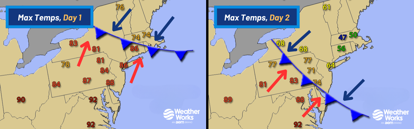
The images above and below show an example of a backdoor coldfront's progressioon over the northeastern US. On Day 1, the front advances into New England late in the day, bringing an increase in cloud cover and lower temperatures into the 60s and 70s. Winds are starting to turn out of the east-northeast, bringing a cooler, maritime airmass off the relatively cold Atlantic Ocean. By Day 2, the area is solidly in this airmass, and with low clouds or even sometimes drizzle present, high temperatures are struggling to reach past 50 degrees in Boston, which is 20t to 30 degrees colder than what occurred a day earlier when highs neared 80. During this particular example, Worcester, MA also set a record "low-maximum" on Day 2 when the high temperature only approached 47 degrees. After the frontal passage, temperatures fell more than 20 degrees in New York City from a high of 86 on Day 1 to only 64 on Day 2.
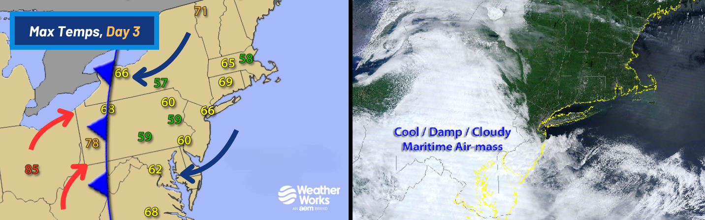
Sometimes, backdoor fronts if strong enough can progress very far. On Day 3 of this example, it did just that as it pushed west before stalling out along the Appalachian Mountains from Western New York to Western Virginia. Backdoor cold fronts are generally "shallow" in nature, with much of the colder, maritime air only extending a few thousand feet above the surface and therefore often having a very difficult time passing over the mountains. Day 3 saw some of the coolest temperatures and thickest cloud cover along and just to the east of the front. Most of New England actually dried out as high pressure built in from the northeast. Still, temperatures remained cool relative to Day 1 in New England. Between Days 2 and 3, high temperatures dropped from 83 to 59 degrees in Harrisburg, PA and from 88 down to 62 in Washington, DC.

As we mentioned, the above example is the most extreme case of Backdoor fronts, and most of the time, they only get hung up around parts of the Mid-Atlantic before pushing back northeast. Still, they can be quite tricky to forecast. It can be the difference between a warm spring day in the 70s and 80s with lots of sun, to a cooler and damp day in the 50s and 60s under lots of cloud cover and even drizzle. Our Meteorologists recognize these patterns and adjust forecasts for potential swings in temperature and wet weather that can have an affect on sensitive outdoor operations like mowing, paving, roofying, etc. If you've had your work operations hampered by unexpected wet weather, it might be time to switch your weather provider. Email us at info@weatherworksinc.com or call 908-850-8600 to see how our weather solutions can help you year round.


