If the topic of record breaking or hard-hitting hurricane seasons came up in conversation between two meteorologists, the near immediate answer would likely include storms from the 2005 Hurricane Season. However, that would only be the case until 2020, when another busy Atlantic hurricane season gave the 2005 season a run for its money and then some. Five years after this historic season, let’s dive deep into how certain parameters played a role in a super active and impactful hurricane season, the storms themselves, and the overall aftermath and impacts.
The first outlook produced by the Climate Prediction Center (CPC) was released on May 21st, 2020. At that point, the CPC called for a 60% chance of an above-average Atlantic season, with only a 30% chance for near-normal and a 10% chance for below-normal. The CPC had a 70% probability for 13 – 19 named storms, 6 – 10 of those being hurricanes and 3 – 6 of those hurricanes being classified as Major (Category 3 or higher). The Accumulated Cyclone Energy (ACE) , which is a measure of overall strength and duration of storms within the season. was also forecasted to be 110% - 190% of the median. The reasoning behind these above-average expectations stems from a combination of above-average sea surface temperatures, weak easterly trade winds and vertical wind shear, and a wetter/stronger west African monsoon. The El-Nino Southern Oscillation (ENSO) was also forecast to remain neutral or potentially transition into a La Nina, and while neutral conditions do not inhibit storm formation or suppress conditions, La Nina would reinforce formation conditions and allow for increased likelihood for an above-average season.
These concerns for an above average hurricane season would only compound, with an updated outlook published in early August from the CPC, increasing probabilities of an above-average hurricane season to 85%, with a significant possibility that the season would be extremely active. By this update, nine storms had already formed since the season began in June, and the updated predicted storm counts were boosted to 19 – 25 storms, of those 7 – 11 would be hurricanes, and 3 – 6 of those hurricanes would be Major. The ACE predictions were also increased to 140 – 230% of the median, which included the previously mentioned nine storms that had formed. Concerns for La Nina conditions to develop increased, which ultimately did end up occurring later in August. This occurrence, combined with the previously mentioned warm sea surface temperatures, weak trade winds/wind shear, and a stronger African monsoon, was shaping up to be a big concern for an explosive hurricane season.
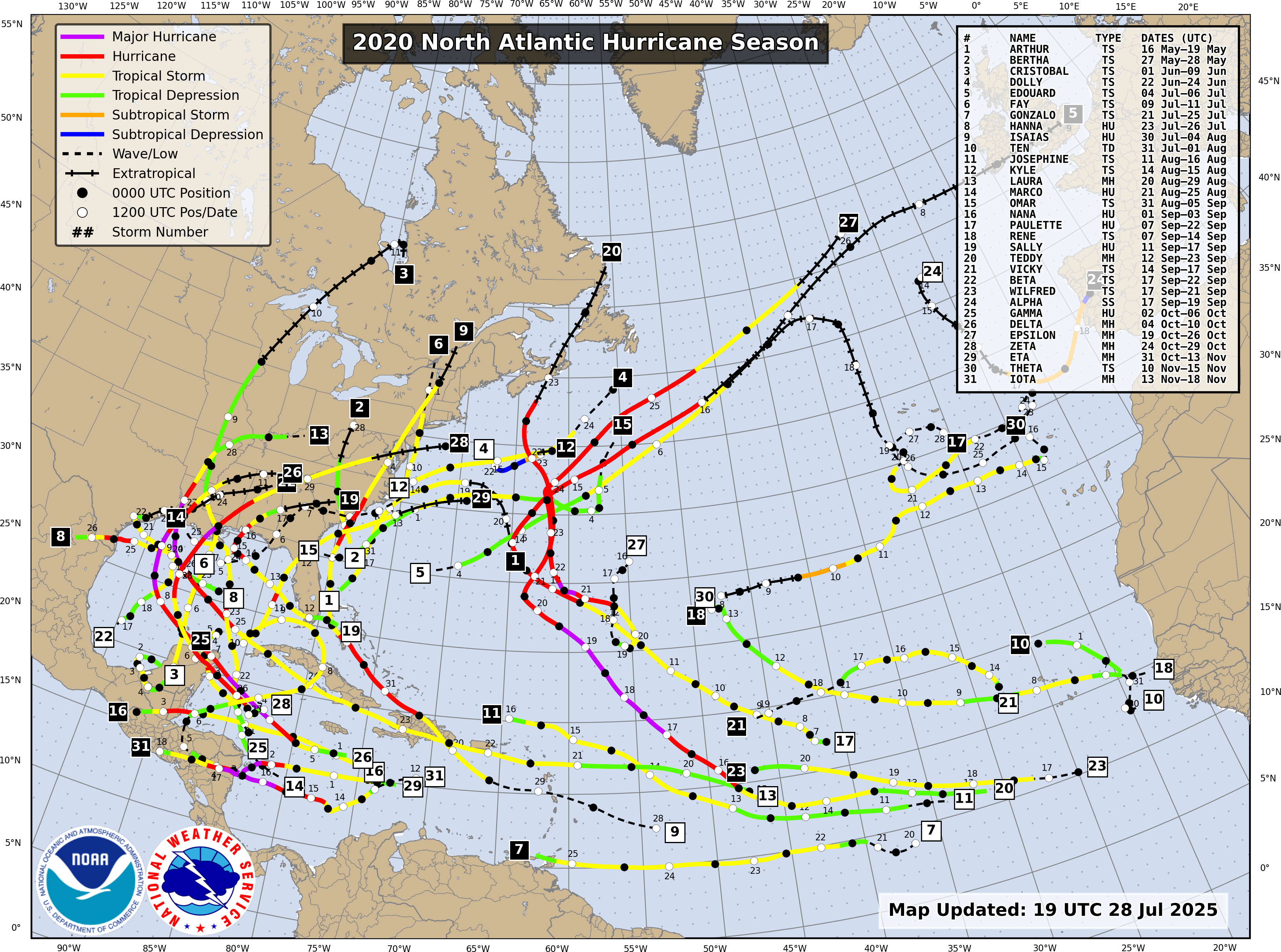
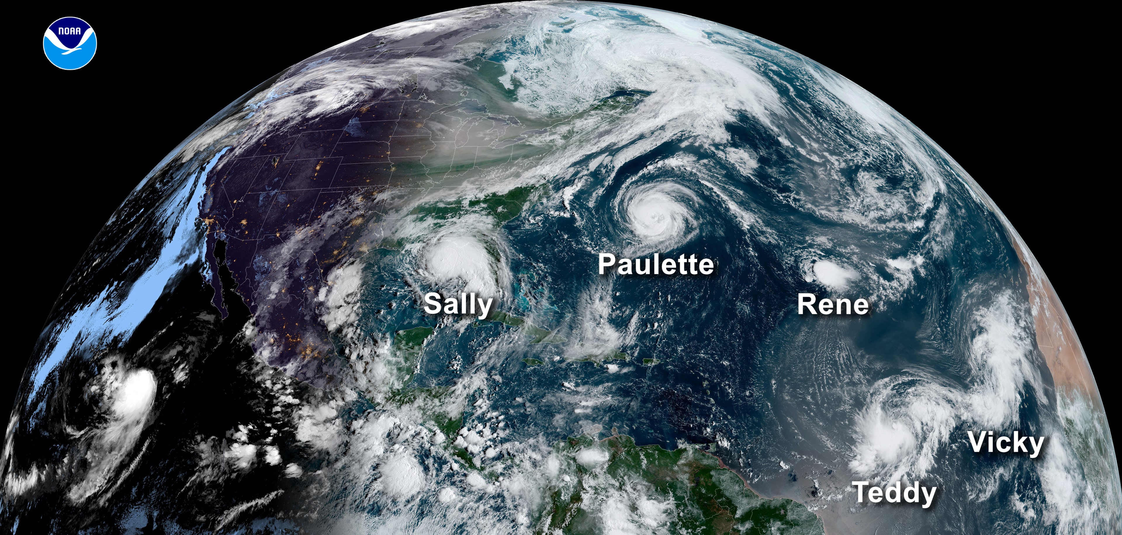
The 2020 Atlantic hurricane season featured 31 tropical systems, 30 of which were named and with just one tropical depression; all of which combined to create the most storms on record and surpassed the 2005 season. This is also the second highest number of hurricanes in a tropical season on record. Fourteen of those named storms developed into hurricanes and a record breaking seven further went on to become Category 3 or higher. Eleven storms made landfall in the continental United States as well, breaking the old record of nine landfalls set in 1916. The first storm of the season, Arthur, developed on May 16th, which was two weeks before the official start of the Atlantic hurricane season. The last storm of the season, Iota, developed on October 30th and dissipated by November 18th. The start of September is usually considered to begin the “peak” of hurricane season, but by that point in 2020, 13 named storms had already occurred, and a 14th storm was named on the first of September. By mid-September, there were five tropical systems in the Atlantic basic at the same time.
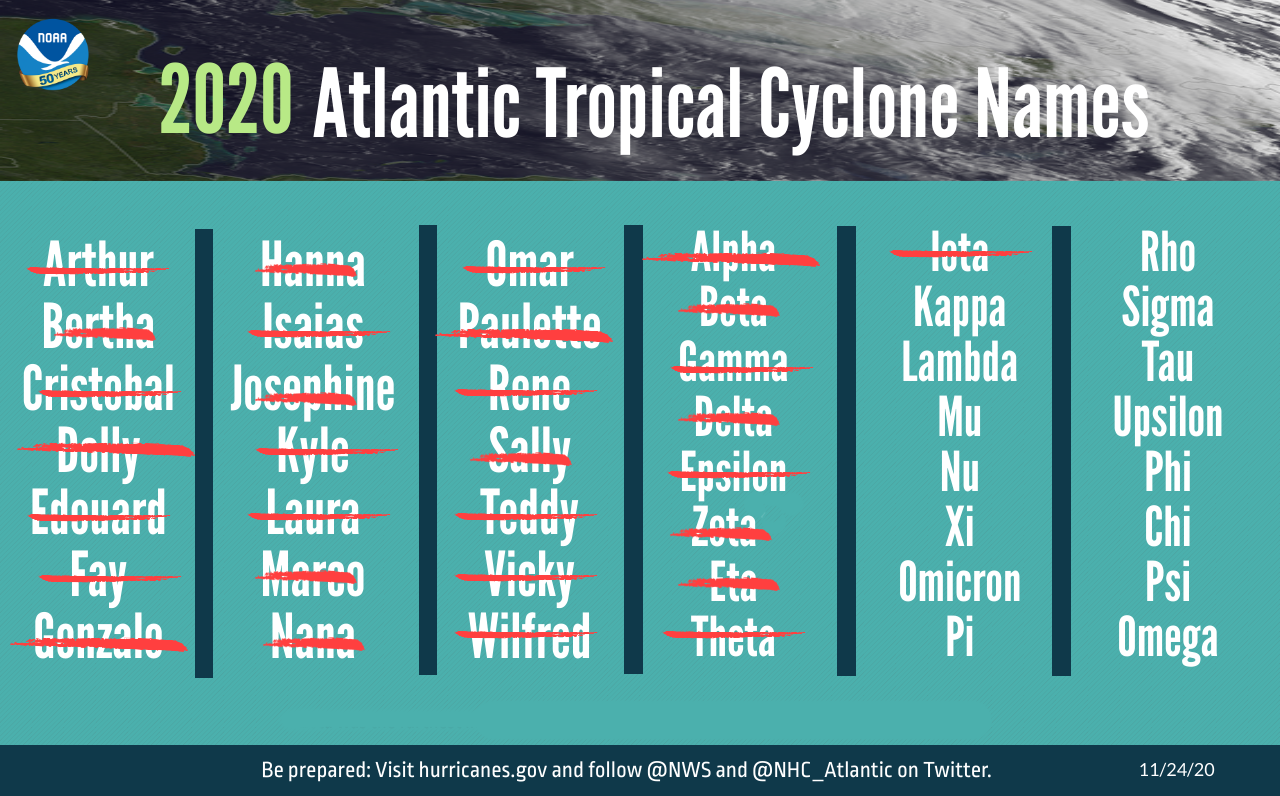
The 2020 hurricane season was also the second season to exhaust all 21 storm names on the designated list for that year, requiring the use of an auxiliary list of Greek names, of which 6 were used. 2020 was the fifth consecutive year with an above-normal hurricane season, attributed to the warm phase of the Atlantic Multi-Decadal Oscillation (AMO) which began in 1995 and has likely aided in stronger, longer-lasting, and more abundant storms since. Twenty-seven tropical storms broke records for the earliest formation date for their respective storm number and ten tropical systems underwent rapid intensification, tying the record with 1995. 2020 was also the first season since 2015 that contained no Category 5 hurricanes, but there were five Category 4 storms, marking another tried record.
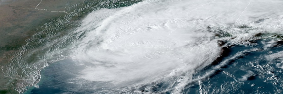
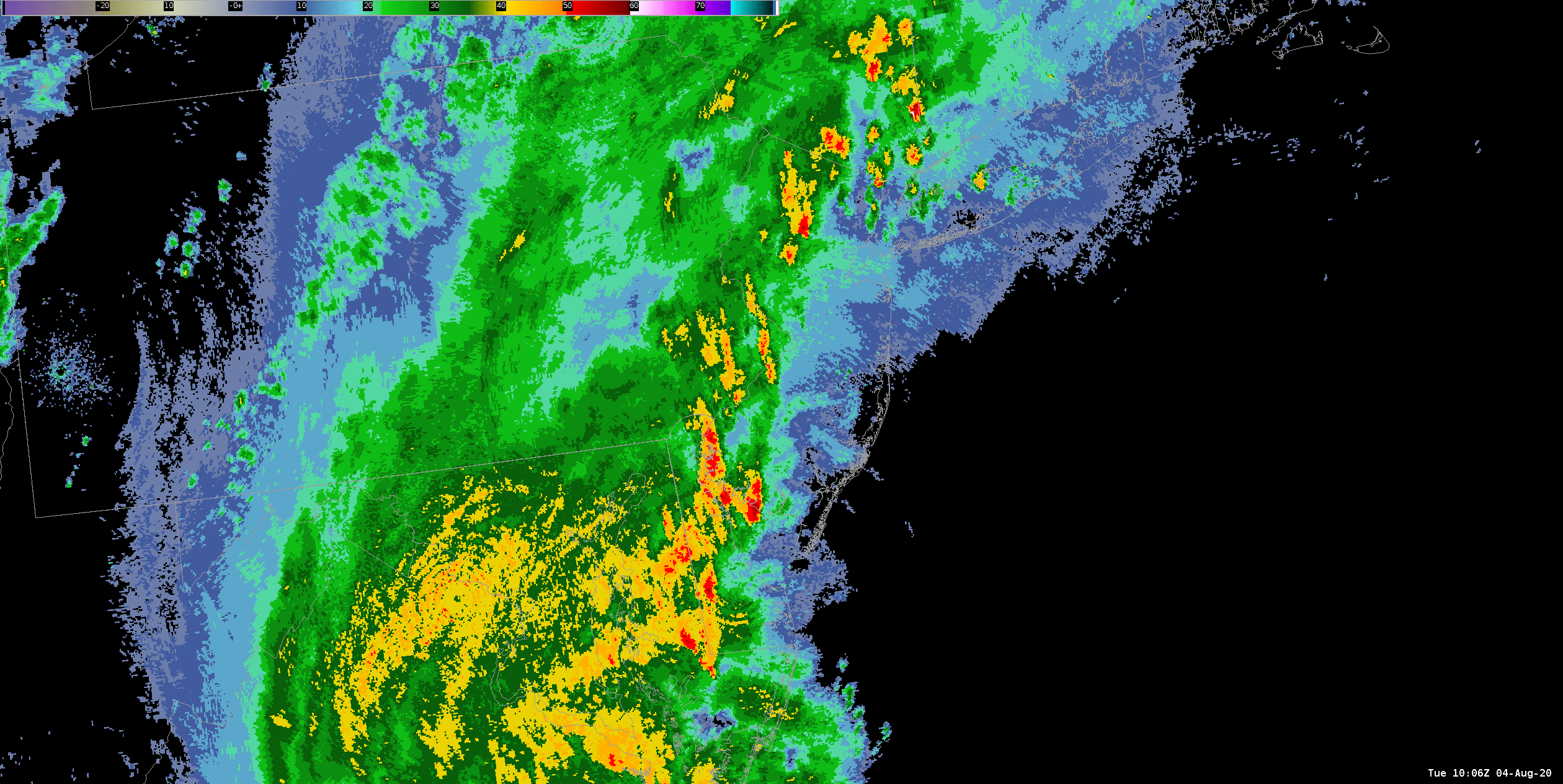
By the time the 2020 Atlantic hurricane season came to a close in mid-November, around $40 billion USD in damages occurred in the United States alone and over 300 fatalities were reported. The most damaging storms for the U.S. were Hanna, Isaias, Laura, Sally, Delta, Zeta, and Eta… all with damage totals pushing over $1 billion. Hurricane Laura was the most damaging hurricane of the season, having even ripped apart the NWS Lake Charles, LA WSR 88-D radar with Category 4 force winds (see image below). The radar was eventually restored in mid-January of 2021. Hurricane Hanna made landfall as a Category 1 hurricane in far southern Texas, resulting in widespread flash flooding, power outages, storm surge, and wind damage.

Hurricane Isaias moved up the eastern seaboard of the US, resulting in over 2.5 million power outages and almost half of them occurring in New Jersey. Several tornadoes developed across the eastern US, with the strongest being an EF-3 in Windsor, NC. A swath of strong winds, locally heavy rainfall, and storm surge occurred across the mid-Atlantic and into New England with Isaias, resulting ultimately in $5 billion in damages and 12 deaths. Hurricane Sally made landfall in southern Alabama as a Category 2 storm, the first landfalling hurricane in Alabama since Ivan in 2004. Sally brought heavy rain, flash flooding, wind damage, and storm surge flooding across several Gulf Coast states. Hurricane Delta was another hurricane that targeted southern Louisiana, making landfall near Creole, LA as a Category 2 hurricane and bringing more instances of flooding, high winds, and storm surge to the Gulf Coast after landfalling just six weeks after Laura. Further causing issues along the Gulf Coast, Hurricane Zeta set sights on Louisiana, landfalling as a Category 3 storm and providing more flooding and wind impacts. Hurricane Eta impacted Florida twice, making a first landfall in the Florida Keys on Nov. 7th and again near Cedar Key on Nov. 12th after doing a loop in the Gulf.
The World Meteorological Organization (WMO) typically retires names of tropical cyclones that end up causing a significant amount of damage or loss of life. That was especially true during the 2020 season, as in March of 2021, they retired the name Laura from being used in future Atlantic hurricane seasons, being replaced by Leah for 2026. The WMO also retired Greek letters of Eta and Iota for similar reasons. After this season, they also discontinued the usage of the Greek alphabet as an auxiliary list for extra storm names for a season. Instead, a new list was made for the 2021 season, which contained an additional 21 names that can be used if needed. Despite 3 names being retired, the WMO did not retire several others that were extensively damaging, such as Isaias and Sally.


