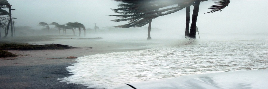
Between breaking records for the greatest number of storms in a season or being the costliest hurricane season on record, until the 2020 season, the 2005 Atlantic hurricane season was one for the record books. This was the first season that the auxiliary list of Greek letters was used, with 28 storms having occurred by the end of the season. Fifteen of those named storms were hurricanes, another record, with 4 of those hurricanes going on to become Category 5 hurricanes. Devastating impacts were left behind, particularly across the Gulf Coast bordering states, with estimated total damage costs coming out over $170 billion and over 3400 lives lost by the end of the season. The season was also quite long, starting June 1st with Arlene and ending January 6th, 2006, with Zeta. With this year marking two decades after this incredibly active season, let's take some time to remember a few of the most impactful storms from 2005.
Hurricane Dennis formed on July 4th, 2005, near the Windward Islands, gradually strengthening into a hurricane by July 6th as it moved westward across the Caribbean Sea. Dennis reached Category 4 status on July 8th before making landfall twice in Cuba, with peak winds around 150 mph before it’s second landfall in the country. Much of Cuba was affected by hurricane force winds and torrential rainfall. This resulted in abundant building damage, loss of power for multiple days, washed away roads, water system contamination, and more. The estimated damage totals in Cuba alone were around $1.4 billion, with 16 lives lost.
Dennis emerged into the Gulf as a Category 1 hurricane on July 9th after being weakened by Cuba’s mountainous terrain. Dennis quickly began to re-organize in the favorable Gulf waters, reaching Category 4 status for a third time on July 10th as the storm approached Florida. The storm weakened slightly before making landfall in the Florida panhandle, near Santa Rosa Island, as a Category 3 hurricane on July 10th. Dennis produced strong winds, heavy rain, and a few weak tornadoes across the state as it landfilled. Dennis also moved onshore with a 6 – 9 ft storm surge that inundated areas along the panhandle. Over 700,000 people lost power across the state of Florida. Many buildings along the western coast were flooded by storm surge, with boats, piers, and more damaged as well. Navarre Beach saw nearly every structure damaged due to winds and flooding. When all was said and done, damage in Florida totaled over $1.5 billion, with 14 fatalities recorded. Significant flooding occurred across western Georgia, Alabama, and eastern Mississippi as well, with many of these areas having just seen heavy rain a few days prior thanks to Hurricane Cindy. Due to the significant damage and loss of life caused by Hurricane Dennis, the World Meteorological Organization retired the name in 2006 so it will never be used again in the Atlantic.
Hurricane Emily was the fifth named storm of the 2005 hurricane season, becoming the first hurricane ever to reach Category 5 status in July. Emily developed on July 11th east of the Lesser Antilles, eventually reaching hurricane status during the evening hours of July 13th before making landfall in Grenada a few hours later during the early morning hours of July 14th. After moving through Grenada, Emily emerged into the Caribbean Sea and moved WNW as it quickly strengthened into a major hurricane by that same afternoon. Emily reached peak intensity later July 17th, with peak winds at 160 mph making Emily Category 5. Emily broke the record for being the strongest Atlantic hurricane before the month of August, which is a record that was set only days earlier by Hurricane Dennis. Hurricane Emily continued with a WNW track, eventually interacting with the Yucatan Peninsula as a Category 4 hurricane on July 18th. This land interaction significantly weakened Emily down to Category 1 by later that day, but this would be short lived as Emily restrengthened once emerging into the warm Gulf waters. This strengthening continued until making a final landfall just south of the Mexico – United States border as a Category 3 hurricane with peak winds of 125 mph.
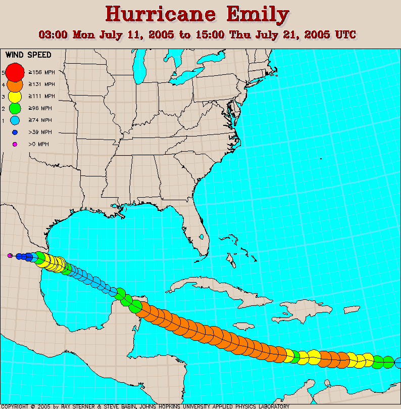
The aftermath of Emily was felt across several countries, with 22 fatalities recorded. Significant flooding and landslides were observed across portions of the Lesser Antilles, with Grenada being one of the hardest hit islands after still recovering from Hurricane Ivan not even a year before. Damage estimates out of Grenada reached over $40 million, with over half of that cost being related to housing damages. Jamaica was another country that was hit hard by the aftermath of Emily’s flooding rains, which had also just been impacted by Dennis as well. Areas of the Yucatan Peninsula recorded significant wind damage as well as impacts from high surf and surge. Rainfall overall was “lighter” in the Yucatan due to the speed in which Emily was moving, but flooding still did occur. Emily’s impacts continued into northeastern Mexico with the final landfall, leading to more extensive flooding, storm surge, mudslides, and wind damage. Mexico’s estimated damage costs were estimated to be over $300 million across the country. The United States also saw impacts from Emily with the final landfall, mainly in the form of heavy rainfall and high tides across far south Texas. Emily also spawned several tornadoes in southern Texas, with the strongest tornado being rated EF1.
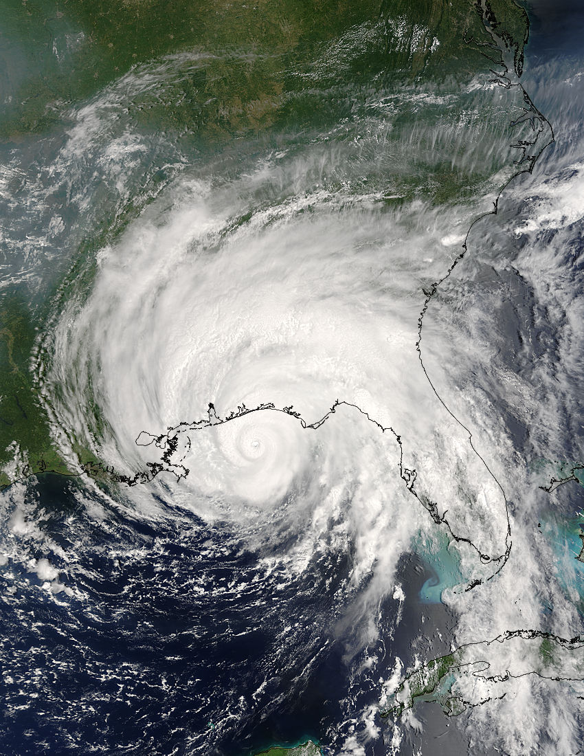
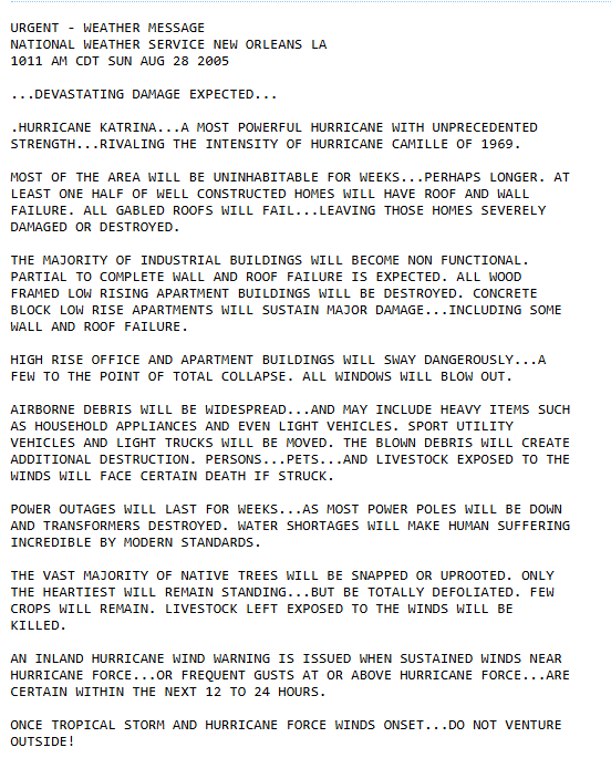
Hurricane Katrina would go on to become one of the most talked about storms from the 2005 hurricane season, having created lasting devastation particularly across portions of southern Louisiana. Katrina became a named storm on the morning of Aug. 24th, forming from a merging of a tropical wave and the remnants of Tropical Depression Ten. Katrina then moved NW towards Florida, reaching hurricane status just a couple of hours before making landfall in far southern Florida on the morning of Aug. 25th. While interacting with Florida, Katrina weakened but this was shortly lived as the storm regained hurricane status about an hour after emerging into the Gulf. Katrina reached Category 3 intensity on Aug. 27th, becoming the third major hurricane of the 2005 season, before intensifying rapidly into a Category 5 hurricane just nine hours later. Katrina reached peak strength on the morning of Aug. 28th, with peak winds of 175 mph and a minimum pressure of 902 millibars, which made Katrina the fifth most intensity Atlantic hurricane at the time before being surpassed by Rita and Wilma later in the season. This was also the strongest hurricane ever recorded in the Gulf of Mexico, before Rita broke that record as well later in the season. Katrina would weaken due to an eyewall replacement cycle before making its second and third landfalls in Buras-Triumph, LA and near the LA – MA border respectively, both as a Category 3 hurricane.
Katrina’s impacts on southern Florida came in the form of localized flooding and wind damage, with portions of the Miami metro area seeing significant flooding. The peak rainfall total in Florida was 16.43” in Perrine. The Florida Keys also saw a tornado, which caused damage to an airport. Over 1.4 million people were left without power and damage in southern Florida was estimated at over $500 million. As Katrina made its final landfall along the Gulf Coast, significant surge impacts and a few tornadoes were noted in the Florida Panhandle.
The impacts from Katrina on southern Louisiana were extensive and devastating, with significant surge observed, though lack of data makes the exact height of surge uncertain. Louisiana also saw heavy rainfall totals, particularly in the eastern part of the state, where 8 – 10” of rainfall was observed. As a result of heavy rainfall and storm surge, Lake Pontchartrain’s water levels rose and caused significant flooding along its northeastern shore and damage to several bridges. In fact, all parishes surrounding the lake saw flooding, with some even seeing storm surge in two rounds… first as the lake rose and then again as the eye of Katrina passed through and strong westerly winds pushed water inland. St. Bernard parish was one of the hardest hit areas, with virtually every structure in the parish damaged by storm surge after the levees failed in the Greater New Orleans area. In fact, because of this, approximately 80% of New Orleans was left flooded. The descriptions of visuals in New Orleans after Katrina moved through are horrific, with a bare bones summary being vast devastation and evidence of death viewable in the streets.
The Gulf coast of Mississippi also saw extensive damage from Katrina, with significant storm surge, heavy rainfall, and strong winds battering the area. Surge crossed I-10 for several miles in many spots, with surge waters reaching ~6 miles inland and ~12 miles inland along bays and rivers. Rainfall totals of 4” or more were observed across much of the state of Mississippi, with totals of 8 – 10” observed in the southwestern portion of the state. Beachfront neighborhoods were completed leveled by this combination of impacts, with preliminary estimates at the time being that 90% of structures within a half mile of the coastline were destroyed. Alabama was also impacted by surge associated with Hurricane Katrina, with measurements being between 12 – 16 ft of surge, which create significant flooding problems several miles inland along Mobile Bay.
When all was said and done, Katrina created damage totals estimated to be around $125 billion, which makes it the costliest hurricane on record (tied with Hurricane Harvey in 2017). The exact death toll is uncertain as reports differ between sources, some by differences of hundreds, but the National Hurricane Center attributes Katrina as the cause for 1,836 fatalities in total and many are still classified as missing. The WMO retired Katrina from the Atlantic hurricane naming lists in April of 2006 due to the high death toll and widespread destruction it caused along the US Gulf Coast.
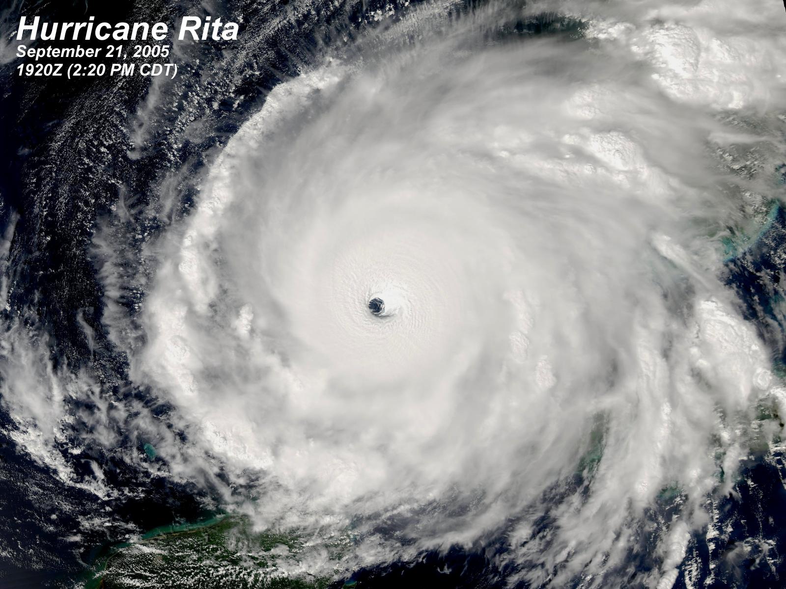
Rita was named as a tropical storm on Sept. 18th, located north of Hispaniola, though was initially struggling to strengthen thanks to strong wind shear. This struggle did not last long, however, as the storm began to strengthen as it moved northwest towards the Florida Keys and by Sept. 20th, Rita strengthened into a Category 1 hurricane. A few hours later, Rita was upgraded to Category 2 status as it passed just south of Key West, FL. Very warm sea surface temperatures aided in the trend of rapid intensification, with Rita intensifying to Category 3 status overnight into Sept. 21st and Category 5 status by the early afternoon hours of that same day. Rita reached peak intensity by the evening of Sept. 21st, with 180 mph winds and a barometric pressure of 895 millibars, making it the strongest tropical system ever recorded in the Gulf of Mexico, and up until that point, the third strongest hurricane in the Atlantic. Rita remains a strong Category 5 hurricane for 18 hours before weakening as an eyewall replacement cycle occurred and eventual interaction with wind shear and cooler waters. Rita made landfall as a Category 3 hurricane in extreme southwestern Louisiana with winds of 115 mph.
Rita brought strong winds, heavy rainfall, and areas of storm surge across southern FL. Homes and businesses were damaged by the surge in the Florida Keys, with storm surge in Key West having moved four blocks inland and streets seeing floodwaters up to 3ft in height. The overall damage on mainland Florida was relatively light in comparison. Rough surf led to some beach erosion along the Florida Panhandle, which exacerbated erosion from previous storms over the season and the prior year. An already devastated Louisiana saw further impacts related to storm surge and flooding thanks to Rita, with areas near Cameron seeing surge in excess of 16ft. Storm surge flooding reached as far inland as Lake Charles, with floodwaters reaching up to 6ft deep downtown. The strongest winds occurred in a very small area near landfall, with extensive damage to structures and infrastructure that authorities said would take weeks to months to repair, but tropical storm forced winds were observed as far east as Baton Rouge. Flooding added strain to the recovery efforts in southeastern Louisiana after Katrina, with levees that had already been repaired in New Orleans seeing damage yet again. New Orleans was still flooded after Katrina as Rita brought impacts to the area, with additional rain and surge keeping the city flooded until October 11th. In Texas, Rita brought significant storm surge inundation to Sabine Pass. Most flooding occurred before Rita made landfall, but northerly winds after Rita moved inland caused the waters of Galveston Bay to flood Galveston Island and the Bolivar Peninsula. Isolated instances of hurricane forced sustained winds also occurred in southeastern Texas. Heavy rainfall was also recorded, with some totals reaching 10 – 12”. Tragedy struck Texas before Rita made its immediate impacts known, with a heat wave having affected the region as between 2 – 3 million were making efforts to evacuate the coastline. The combination of severe gridlock associated with the evacuation process, and the excessive temperatures lead to fatalities before the storm even arrived. This tragic situation combined with the impacts felt from Rita itself lead to 120 fatalities. Due to the widespread damage along the Gulf Coast, Rita was retired from the Atlantic hurricane naming lists in April 2006.
The last system we will talk about is Wilma, which was named on October 17th. Intensification was initially slow due to Wilma’s larger size and flatter pressure gradient, but convection gradually organized, and Wilma intensified into a hurricane on Oct. 18th. As Wilma moved through the Caribbean Sea, it underwent very rapid intensification, with the barometric pressure dropping from 982 to 882 millibars in 30 hours. This pressure reading made Wilma the most intense Atlantic hurricane on record based on pressure. During this same 30-hour window, winds increased to a peak intensity of 185 mph, making Wilma a Category 5 hurricane. An eyewall replacement cycle weakened Wilma below Category 5 status on Oct. 20th as it moved northwestward towards the Yucatan Peninsula, eventually making landfall there late on Oct. 21st with winds at 150 mph. A second landfall was observed near Puerto Morelos with winds further reduced to 135 mph. Additional weakening occurred with this interaction with land, emerging into the Gulf as a Category 2 hurricane, but strengthening occurred as the storm moved back over water. Wilma re-intensified into a major hurricane on Oct. 24th before making landfall near Cape Romano in southwest Florida. The hurricane quickly moved across the state, emerging into the Atlantic as a Category 2 hurricane near Jupiter, FL. From there, Wilma briefly re-intensified to a Category 3 hurricane as it passed north of the Bahamas later on Oct. 24th and continued northeast rapidly.
Wilma brought heavy rainfall to Haiti and the Dominican Republic for several days as the storm developed, which created flooding issues and landslides. In western Cuba, gusty winds, high tides, and heavy rainfall lead to property damage, loss of crops, damage to infrastructure, and power outages. The Yucatan Peninsula experienced significant storm surge and strong winds, with some parts of the Peninsula having experienced hurricane-forced wind gusts for almost 50 hours. In Florida, Wilma’s swift movement across the state mitigated worse issues associated with rainfall, with totals across the state largely ranging from 1 – 7”. Storm surge issues were observed across the state, with heights generally ranging 4 – 8 ft. Wilma produced 12 tornadoes across the state as well. The main impact from Wilma to the state of Florida, though, was wind damage as Wilma’s very large eye moved across several counties in southern Florida. This resulted in widespread power outages, with roughly 98% of the Miami metro electrical customers seeing issues. Florida’s crops were hit hard, with sugarcane and citrus crops experiencing expensive losses. Due to the widespread damage associated with Wilma, the World Meteorological Organization retired the name from the Atlantic hurricane naming lists in April 2006.


