Tornadoes are not uncommon in the weather world, and while each have their own unique impacts, there certainly have been a few tornadoes in history that stand out from the rest for a variety of reasons. We’ll be taking a deep dive into some of the more notable tornadoes across the United States in the past several years, many of which hold some pretty significant records to this day.
First up on our list is the Tri-State Tornado, which has maintained its' status of the longest path of a single tornado for over a century. On March 18, 1925, an area of low pressure tracked from northwest Arkansas into eastern Indiana through the afternoon hours. Ahead of that low pressure was a warm front that lifted northward, pushing warm and moist Gulf air into the region. This, combined with other factors aloft, created an environment conducive for severe weather and tornadoes to develop. What came out of this environment was a complex of storms that produced tornadoes starting near Ellington, MO and ending up near Petersburg, IN.
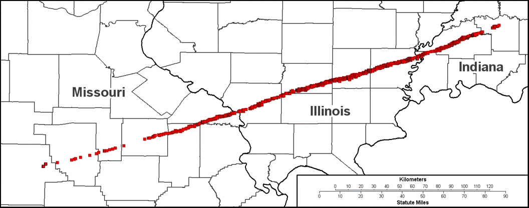
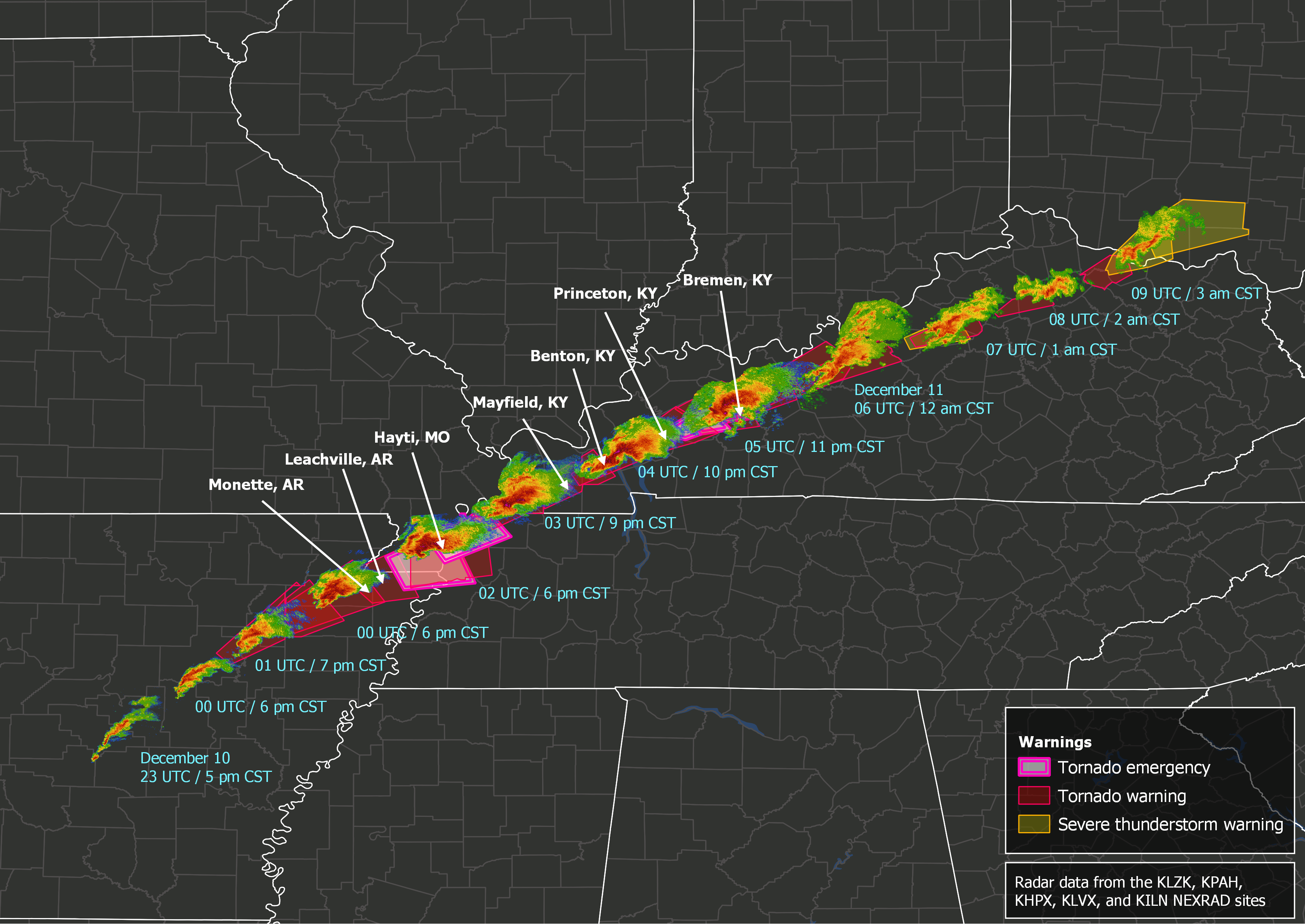
The entirety of the tornadoe's path is believed to not have been fully on the ground during the duration of it's life cycle, with a few gaps in damage noted near the beginning and toward the end of the path, spanning an impressive 235 miles. However, a section of the path from southeastern Shannon County, MO to western Pike County, IN is the most likely segment to have remained on the ground during the entire duration, which spans only a length of 219 miles. To this day, this is the longest recognized path length for a single tornado. This F5-equivalent tornado also holds the record for most tornado-related fatalities in the United States, with an estimated 689 – 695 fatalities across three states and over 2,000 injuries. The only other system that produced tornadoes with a path length that rivals the Tri-State Tornado comes from the December 10 – 11, 2021 outbreak, which produced several strong tornadoes across Arkansas, Missouri, Illinois, Tennessee, and Kentucky. While it originally was dubbed the "Quad State Tornado" by the media, it was discovered that there were actually two long-lived EF4 tornadoes with less intense tornadoes in between, breaking up the potential 250-mile path that would have dethroned the Tri-State tornado.
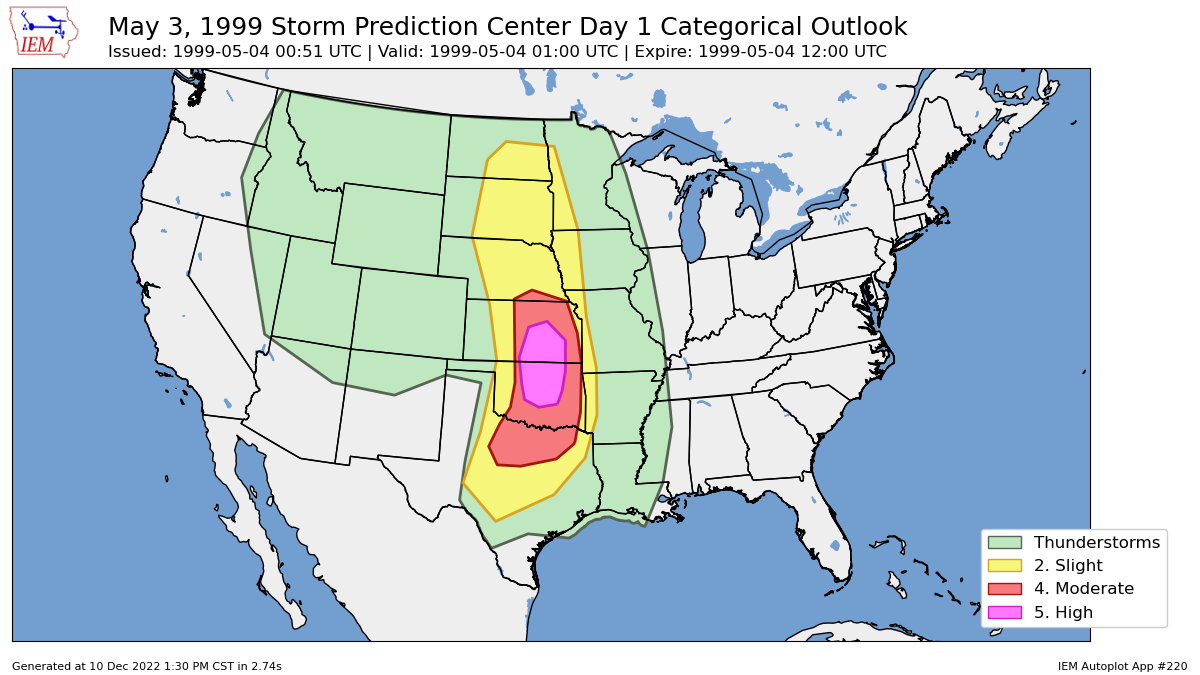
One of the most infamous tornado outbreaks took shape on May 3, 1999 when the combination of a dryline, an upper-level low pressure system, and ample Gulf moisture met up across portions of Oklahoma, northern Texas, and southern Kansas. Because of such, a rare “high” risk was issued by the Storm Prediction Center during the afternoon, with initial storms developing in southwestern Oklahoma as this outlook was published shortly before 4 PM CDT. You can see the older forecast map below.
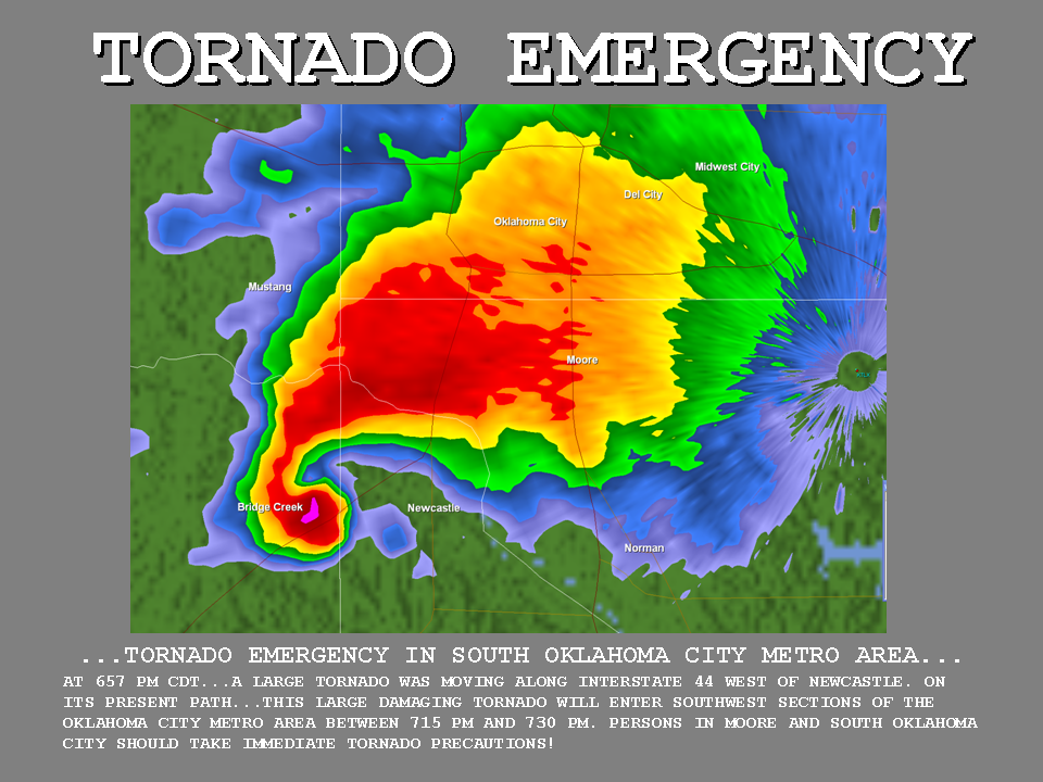
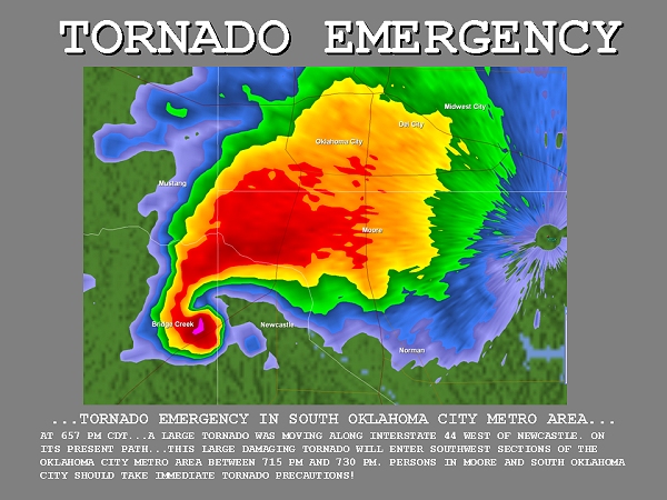
The first tornado warning was issued at 4:47 PM CDT and it was this tornado-producing storm that tracked into Bridge Creek and Moore, OK between 6:23 and 7:48 PM CDT, producing F5 damage across the area. It is also because of this tornado that the first ever "tornado emergency" was issued at 6:57 PM. This was drafted by a meteorologist at the National Weather Service (NWS) office in Norman, OK as the tornado tracked towards the most populous center of Oklahoma: Oklahoma City. When all was said and done, the tornado carved a path of destruction equivalent to $1.9 billion in 2026 costs, as well as 36 fatalities and over 550 injuries. Abundant warning and collaboration with local TV stations likely contributed to keeping these fatalities on the “lower” side. Outside of the tornado that began tornado emergencies from the National Weather Service, this storm was also sampled by the University of Oklahoma’s Doppler on Wheels (Also known as the "DoW") mobile radar with recorded winds of 321 mph making it the highest wind speed ever recorded in a tornado.
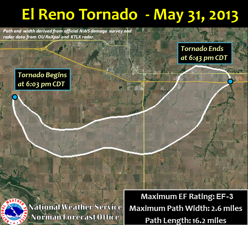
Our next well-known tornado on the list holds the record for being the widest on record. That one came on May 13, 2013 with the El Reno, Oklahoma tornado. This tornado, while only an EF-3, is notable because of the wide nature of it as well as its complex path and intense mesovortices (small, intense vortexes) that moved around it. The tornado developed at 6:03 PM CDT and initially moved southeast, but after five minutes it shifted and turned toward the east while also speeding up. This is also when the aformentioned mesovortices were first detected in the tornado. After a series of additional abrupt turns in track and changes in forward speed, the tornado dissipated at 6:42 PM CDT. The tornado reached a maximum width of 2.6 miles, with estimated wind speeds of 200mph detected by a DoW mobile radar and RaXPol radar. Because the Enhanced Fujuta scale (EF) are determined by damage, and the fact these intense winds barely had any structural damage along it's path, the tornado was given a lower rating at an EF-3, which is something that is still a topic of debate to this day amongst meteorologists. Eight fatalities occurred with this tornado, all within vehicles. These included three storm chasers: Tim Samaras, Paul Samaras and Carl Young, as the tornado unfortuinately moved over their location.
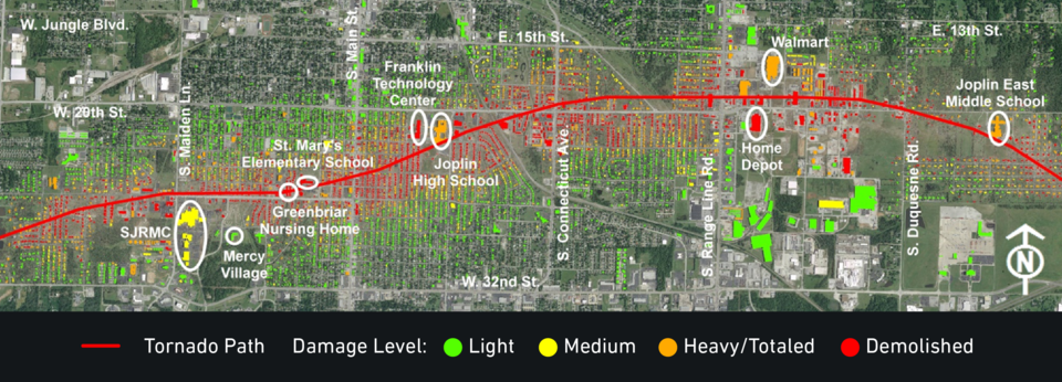
With the advanced strides in warning lead times and communication, it is exceptionally unlikely to see fatalities from a tornado reach over 100 in modern times. But in fact, before the tornado we are going to discuss about, the last time a tornado resulted in over 100 fatalities was in Flint, MI in 1953. On May 22, 2011, 159 people lost their lives and over 1,000 people were left injured after an EF-5 tornado tore through the community of Joplin, MO. It began just to the west of Joplin at 5:34 PM CDT, eventually reaching a peak width of ~1 mile as it moved through the southern part of the city before dissipating at 6:12 PM CDT near Diamond, MO. In the end, the Joplin tornado resulted in $2.8 billion in damage costs, which is the costliest tornado in U.S. history ($4.01 billion in 2025). Afterwards, the NWS Central Region office did a survey and service assessment to examine warning and forecast services, due to the rarity and historical significance of what had occurred. It was concluded that many Joplin residents interviewed did not immediately heed warnings that were put into place, or the sirens that went off. Instead, many of those interviewed chose to wait and actively seek additional information, such as confirmation of a tornado, likely because of previous “false alarms” when sirens or warnings have gone off with no tornado. These findings resulted in discussions surrounding desensitization from warnings and how to adequately warn the public in a way that initiates a response during dangerous storm situations, which are conversations for improvement still to this day.
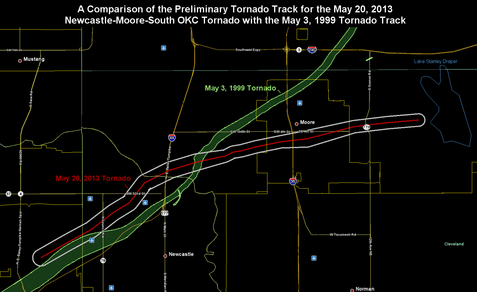
The beginning of the EF-5 “drought” started on May 20, 2013, as the last recorded EF-5 was the Moore, OK tornado. No, you are not misreading that; Moore indeed was hit again after the1999 F5 raveged the city. The environment was prime for storm development with a dryline nearby and abundant Gulf moisture, which began to produce storms that quickly intensified. The storm that would go on to produce the 2013 Moore tornado started near Chickasha with touchdown at 2:56 PM CDT near Newcastle, moving east-northeast into Moore. The tornado would eventually dissipate near Lake Stanley Draper, but over the 39 minutes the tornado was on the ground, it led to 24 fatalities, 7 of which occurred at Plaza Towers Elementary School. While there have been strong tornadoes since 2013 in the US, it would take 12 years for a tornado to reach EF-5 status. Remember, that the EF scale is determined by damage and not wind speeds, so it's plausabile there were tornadoes that had EF-5 potential in 12 years, just without any damage to show for it.
Fast forward to June 20, 2025 in Enderlin, ND when storms were developing to the southwest and began to strengthen. These headed east-northeast near the rural town after 11:00 PM CDT. The tornado ended up wreaking havoc on trees, crops, rural houses and outbuildings, along with train cars before lifting around 11:20 PM CDT. Even with all of this damage evidence, the initial rating out of Enderlin, ND was not EF-5 , in fact the NWS office in Grand Forks originally gave it an EF-3 rating. It would take the efforts of several engineers, combined with continued efforts from the NWS in Grand Forks, to ultimately upgrade the Enderlin tornado to an EF-5 in October of 2025.
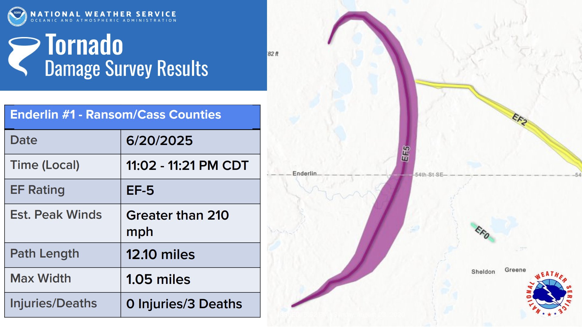
The reasoning: due to the reassessment of the train car damage by the tornado, with 19 of the 33 cars being fully loaded with grain that weighed up to 286,000 lbs, it was determined that winds of 210 mph or greater were needed to tip them over, with winds over 266 mph required to throw them. Before the reanalysis, the damage to the train cars was not rated, as train cars are not standard damage indicators in the survey process. Three people lost their life as a result of the Enderlin tornado.